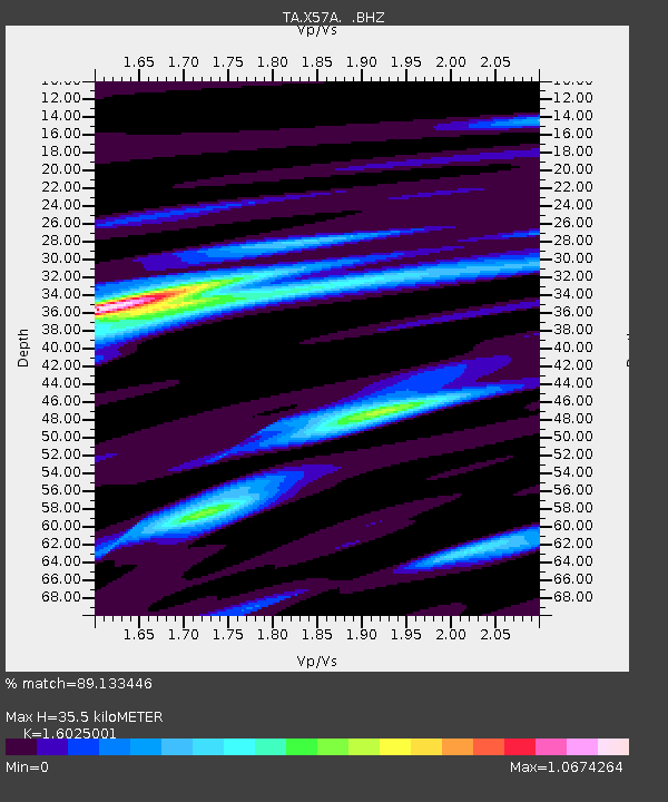
X57A Johnson Farm, Hartsville, SC, USA - Earthquake Result Viewer
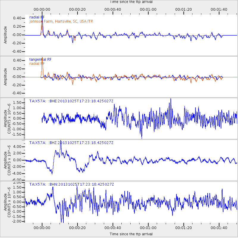
Earthquake location: Off East Coast Of Honshu, Japan
Earthquake latitude/longitude: 37.2/144.7
Earthquake time(UTC): 2013/10/25 (298) 17:10:19 GMT
Earthquake Depth: 35 km
Earthquake Magnitude: 7.1 MWW, 7.1 MWW, 7.1 MWB, 7.1 MWC, 7.2 MWC, 7.5 MI
Earthquake Catalog/Contributor: NEIC PDE/NEIC COMCAT
Network: TA USArray Transportable Network (new EarthScope stations)
Station: X57A Johnson Farm, Hartsville, SC, USA
Lat/Lon: 34.46 N/80.09 W
Elevation: 133 m
Distance: 97.5 deg
Az: 35.925 deg
Baz: 325.436 deg
Ray Param: 0.040187206
Estimated Moho Depth: 35.5 km
Estimated Crust Vp/Vs: 1.60
Assumed Crust Vp: 6.419 km/s
Estimated Crust Vs: 4.006 km/s
Estimated Crust Poisson's Ratio: 0.18
Radial Match: 89.133446 %
Radial Bump: 400
Transverse Match: 63.88504 %
Transverse Bump: 400
SOD ConfigId: 626651
Insert Time: 2014-04-19 06:20:22.316 +0000
GWidth: 2.5
Max Bumps: 400
Tol: 0.001

Signal To Noise

ChannelStoNSTALTA
TA:X57A: :BHZ:20131025T17:23:18.425027Z10.6237331.5629795E-61.471215E-7
TA:X57A: :BHN:20131025T17:23:18.425027Z2.6647524.714078E-71.7690495E-7
TA:X57A: :BHE:20131025T17:23:18.425027Z1.58365653.796565E-72.397341E-7
Arrivals
Ps3.4 SECOND
PpPs14 SECOND
PsPs/PpSs17 SECOND