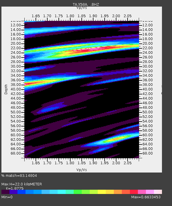
X58A Rowland, NC, USA - Earthquake Result Viewer

Earthquake location: Off East Coast Of Honshu, Japan
Earthquake latitude/longitude: 37.2/144.7
Earthquake time(UTC): 2013/10/25 (298) 17:10:19 GMT
Earthquake Depth: 35 km
Earthquake Magnitude: 7.1 MWW, 7.1 MWW, 7.1 MWB, 7.1 MWC, 7.2 MWC, 7.5 MI
Earthquake Catalog/Contributor: NEIC PDE/NEIC COMCAT
Network: TA USArray Transportable Network (new EarthScope stations)
Station: X58A Rowland, NC, USA
Lat/Lon: 34.55 N/79.34 W
Elevation: 45 m
Distance: 97.7 deg
Az: 35.354 deg
Baz: 325.937 deg
Ray Param: 0.040102977
Estimated Moho Depth: 22.0 km
Estimated Crust Vp/Vs: 1.88
Assumed Crust Vp: 6.565 km/s
Estimated Crust Vs: 3.496 km/s
Estimated Crust Poisson's Ratio: 0.30
Radial Match: 83.14804 %
Radial Bump: 400
Transverse Match: 55.20028 %
Transverse Bump: 400
SOD ConfigId: 626651
Insert Time: 2014-04-19 06:20:25.065 +0000
GWidth: 2.5
Max Bumps: 400
Tol: 0.001

Signal To Noise

ChannelStoNSTALTA
TA:X58A: :BHZ:20131025T17:23:19.650002Z8.5391091.6269285E-61.905267E-7
TA:X58A: :BHN:20131025T17:23:19.650002Z1.81228654.7580687E-72.6254506E-7
TA:X58A: :BHE:20131025T17:23:19.650002Z1.06424493.0971486E-72.910184E-7
Arrivals
Ps3.0 SECOND
PpPs9.5 SECOND
PsPs/PpSs12 SECOND