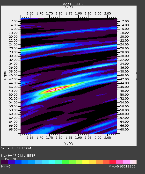
Y51A Rockmart, GA, USA - Earthquake Result Viewer
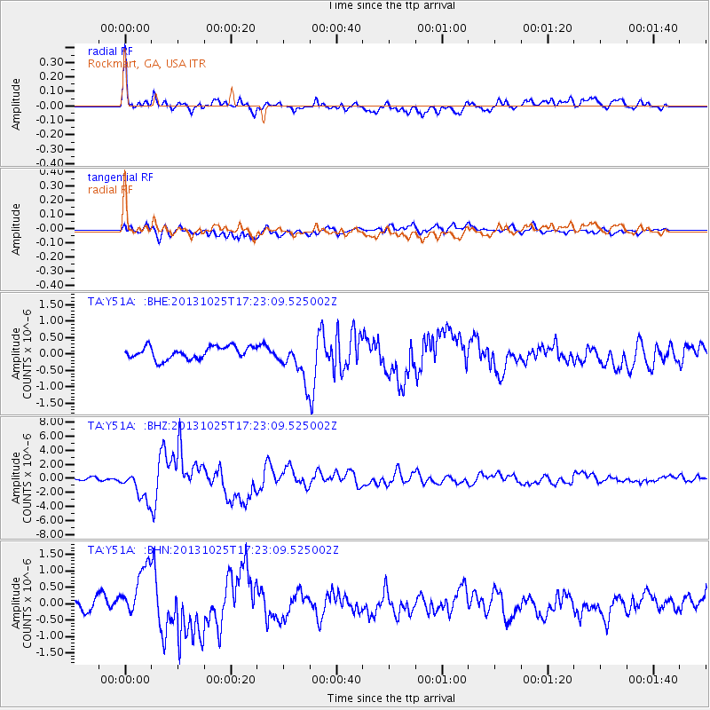
Earthquake location: Off East Coast Of Honshu, Japan
Earthquake latitude/longitude: 37.2/144.7
Earthquake time(UTC): 2013/10/25 (298) 17:10:19 GMT
Earthquake Depth: 35 km
Earthquake Magnitude: 7.1 MWW, 7.1 MWW, 7.1 MWB, 7.1 MWC, 7.2 MWC, 7.5 MI
Earthquake Catalog/Contributor: NEIC PDE/NEIC COMCAT
Network: TA USArray Transportable Network (new EarthScope stations)
Station: Y51A Rockmart, GA, USA
Lat/Lon: 33.90 N/85.06 W
Elevation: 380 m
Distance: 95.5 deg
Az: 39.606 deg
Baz: 322.239 deg
Ray Param: 0.04075219
Estimated Moho Depth: 47.0 km
Estimated Crust Vp/Vs: 1.78
Assumed Crust Vp: 6.719 km/s
Estimated Crust Vs: 3.775 km/s
Estimated Crust Poisson's Ratio: 0.27
Radial Match: 87.13974 %
Radial Bump: 400
Transverse Match: 61.180214 %
Transverse Bump: 400
SOD ConfigId: 626651
Insert Time: 2014-04-19 06:20:37.016 +0000
GWidth: 2.5
Max Bumps: 400
Tol: 0.001

Signal To Noise

ChannelStoNSTALTA
TA:Y51A: :BHZ:20131025T17:23:09.525002Z7.6404252.139833E-62.8006727E-7
TA:Y51A: :BHN:20131025T17:23:09.525002Z3.6719828.163709E-72.2232432E-7
TA:Y51A: :BHE:20131025T17:23:09.525002Z3.16413385.916363E-71.8698206E-7
Arrivals
Ps5.6 SECOND
PpPs19 SECOND
PsPs/PpSs25 SECOND