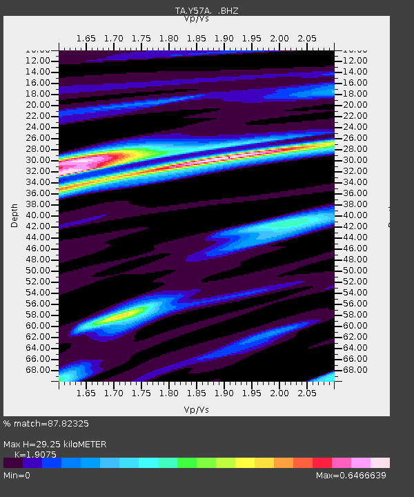
Y57A Sumter, SC, USA - Earthquake Result Viewer
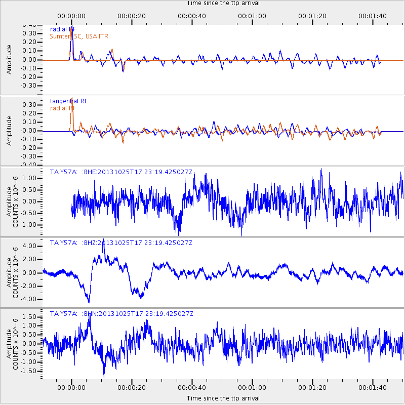
Earthquake location: Off East Coast Of Honshu, Japan
Earthquake latitude/longitude: 37.2/144.7
Earthquake time(UTC): 2013/10/25 (298) 17:10:19 GMT
Earthquake Depth: 35 km
Earthquake Magnitude: 7.1 MWW, 7.1 MWW, 7.1 MWB, 7.1 MWC, 7.2 MWC, 7.5 MI
Earthquake Catalog/Contributor: NEIC PDE/NEIC COMCAT
Network: TA USArray Transportable Network (new EarthScope stations)
Station: Y57A Sumter, SC, USA
Lat/Lon: 34.02 N/80.39 W
Elevation: 56 m
Distance: 97.7 deg
Az: 36.385 deg
Baz: 325.208 deg
Ray Param: 0.040118866
Estimated Moho Depth: 29.25 km
Estimated Crust Vp/Vs: 1.91
Assumed Crust Vp: 6.419 km/s
Estimated Crust Vs: 3.365 km/s
Estimated Crust Poisson's Ratio: 0.31
Radial Match: 87.82325 %
Radial Bump: 400
Transverse Match: 65.24843 %
Transverse Bump: 400
SOD ConfigId: 626651
Insert Time: 2014-04-19 06:20:51.375 +0000
GWidth: 2.5
Max Bumps: 400
Tol: 0.001

Signal To Noise

ChannelStoNSTALTA
TA:Y57A: :BHZ:20131025T17:23:19.425027Z6.1657461.4697773E-62.3837784E-7
TA:Y57A: :BHN:20131025T17:23:19.425027Z1.50491074.7613673E-73.163887E-7
TA:Y57A: :BHE:20131025T17:23:19.425027Z1.40210514.4683972E-73.1869203E-7
Arrivals
Ps4.2 SECOND
PpPs13 SECOND
PsPs/PpSs17 SECOND