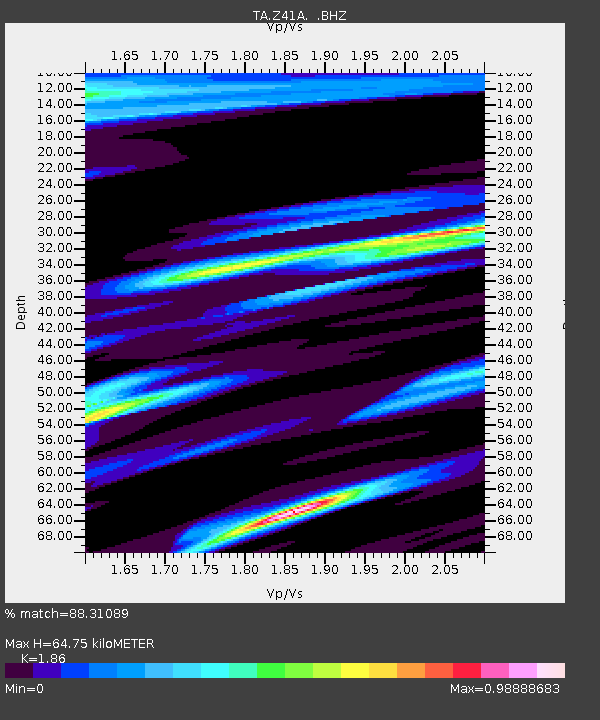
Z41A Richland Creek Farm, El Dorado, AR, USA - Earthquake Result Viewer
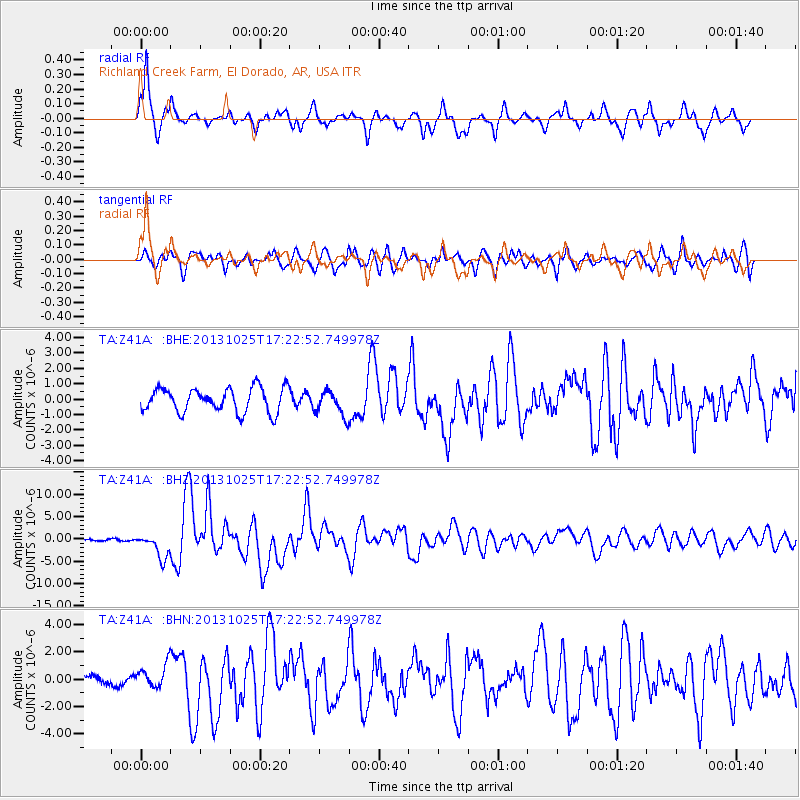
Earthquake location: Off East Coast Of Honshu, Japan
Earthquake latitude/longitude: 37.2/144.7
Earthquake time(UTC): 2013/10/25 (298) 17:10:19 GMT
Earthquake Depth: 35 km
Earthquake Magnitude: 7.1 MWW, 7.1 MWW, 7.1 MWB, 7.1 MWC, 7.2 MWC, 7.5 MI
Earthquake Catalog/Contributor: NEIC PDE/NEIC COMCAT
Network: TA USArray Transportable Network (new EarthScope stations)
Station: Z41A Richland Creek Farm, El Dorado, AR, USA
Lat/Lon: 33.26 N/92.80 W
Elevation: 62 m
Distance: 91.8 deg
Az: 44.971 deg
Baz: 317.632 deg
Ray Param: 0.04154254
Estimated Moho Depth: 64.75 km
Estimated Crust Vp/Vs: 1.86
Assumed Crust Vp: 6.245 km/s
Estimated Crust Vs: 3.358 km/s
Estimated Crust Poisson's Ratio: 0.30
Radial Match: 88.31089 %
Radial Bump: 400
Transverse Match: 77.632515 %
Transverse Bump: 400
SOD ConfigId: 626651
Insert Time: 2014-04-19 06:20:56.400 +0000
GWidth: 2.5
Max Bumps: 400
Tol: 0.001

Signal To Noise

ChannelStoNSTALTA
TA:Z41A: :BHZ:20131025T17:22:52.749978Z14.9601212.7761307E-61.8556874E-7
TA:Z41A: :BHN:20131025T17:22:52.749978Z1.11798458.415003E-77.5269406E-7
TA:Z41A: :BHE:20131025T17:22:52.749978Z1.0450368.14945E-77.798248E-7
Arrivals
Ps9.1 SECOND
PpPs29 SECOND
PsPs/PpSs38 SECOND