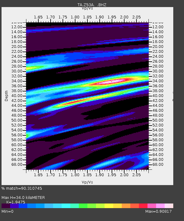
Z53A Monticello, GA, USA - Earthquake Result Viewer

Earthquake location: Off East Coast Of Honshu, Japan
Earthquake latitude/longitude: 37.2/144.7
Earthquake time(UTC): 2013/10/25 (298) 17:10:19 GMT
Earthquake Depth: 35 km
Earthquake Magnitude: 7.1 MWW, 7.1 MWW, 7.1 MWB, 7.1 MWC, 7.2 MWC, 7.5 MI
Earthquake Catalog/Contributor: NEIC PDE/NEIC COMCAT
Network: TA USArray Transportable Network (new EarthScope stations)
Station: Z53A Monticello, GA, USA
Lat/Lon: 33.28 N/83.57 W
Elevation: 144 m
Distance: 96.7 deg
Az: 38.986 deg
Baz: 323.127 deg
Ray Param: 0.040407423
Estimated Moho Depth: 34.0 km
Estimated Crust Vp/Vs: 1.95
Assumed Crust Vp: 6.565 km/s
Estimated Crust Vs: 3.371 km/s
Estimated Crust Poisson's Ratio: 0.32
Radial Match: 90.310745 %
Radial Bump: 400
Transverse Match: 78.30954 %
Transverse Bump: 400
SOD ConfigId: 626651
Insert Time: 2014-04-19 06:21:06.440 +0000
GWidth: 2.5
Max Bumps: 400
Tol: 0.001

Signal To Noise

ChannelStoNSTALTA
TA:Z53A: :BHZ:20131025T17:23:15.150002Z9.0775051.665527E-61.8347849E-7
TA:Z53A: :BHN:20131025T17:23:15.150002Z2.15365674.690882E-72.178101E-7
TA:Z53A: :BHE:20131025T17:23:15.150002Z3.47504546.55929E-71.8875407E-7
Arrivals
Ps5.0 SECOND
PpPs15 SECOND
PsPs/PpSs20 SECOND