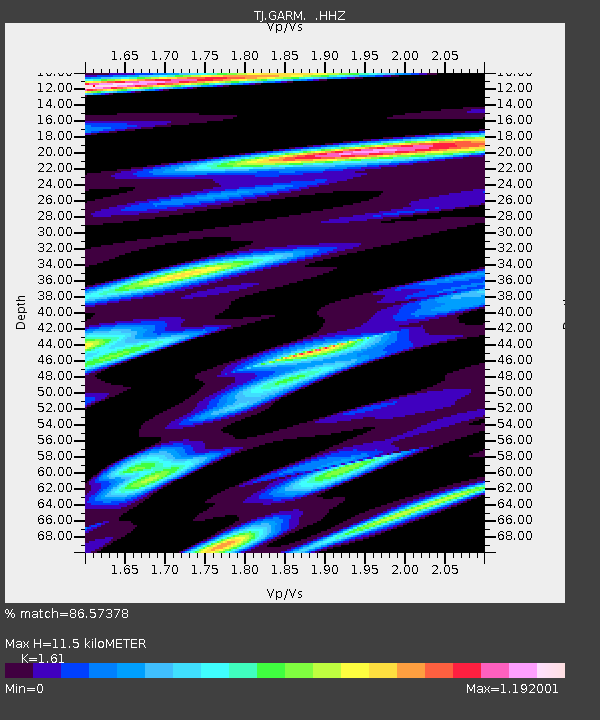
GARM Garm, Tajikistan - Earthquake Result Viewer
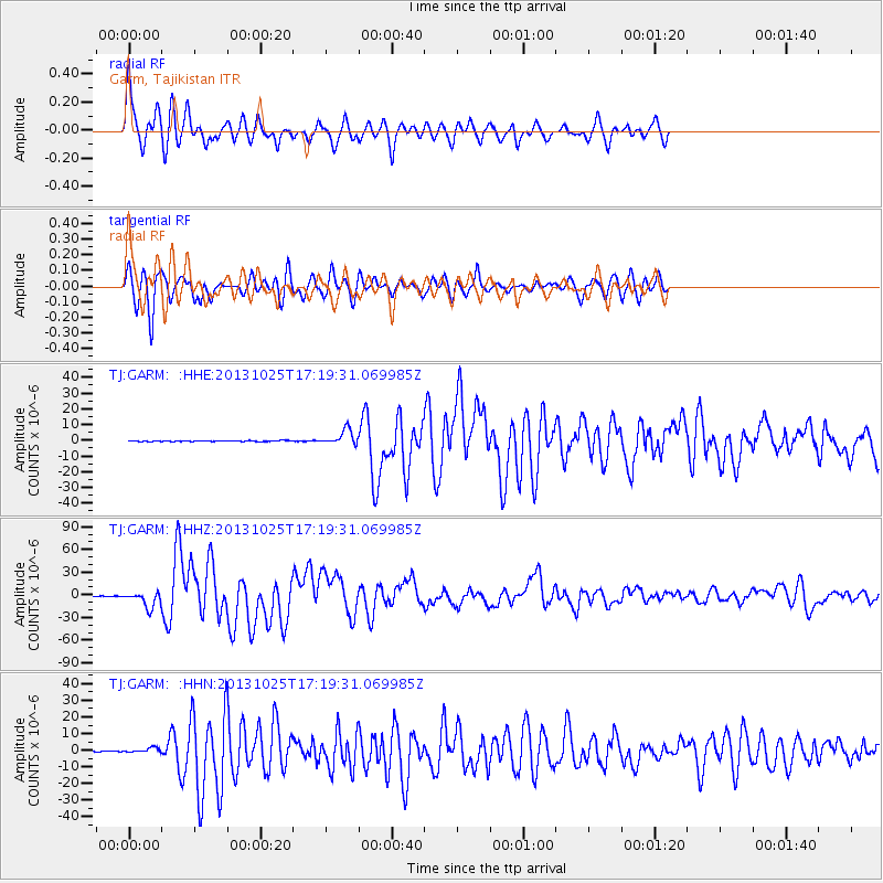
Earthquake location: Off East Coast Of Honshu, Japan
Earthquake latitude/longitude: 37.2/144.7
Earthquake time(UTC): 2013/10/25 (298) 17:10:19 GMT
Earthquake Depth: 35 km
Earthquake Magnitude: 7.1 MWW, 7.1 MWW, 7.1 MWB, 7.1 MWC, 7.2 MWC, 7.5 MI
Earthquake Catalog/Contributor: NEIC PDE/NEIC COMCAT
Network: TJ Tajikistan National Seismic Network
Station: GARM Garm, Tajikistan
Lat/Lon: 39.00 N/70.32 E
Elevation: 1305 m
Distance: 57.0 deg
Az: 296.513 deg
Baz: 66.563 deg
Ray Param: 0.063722044
Estimated Moho Depth: 11.5 km
Estimated Crust Vp/Vs: 1.61
Assumed Crust Vp: 6.306 km/s
Estimated Crust Vs: 3.917 km/s
Estimated Crust Poisson's Ratio: 0.19
Radial Match: 86.57378 %
Radial Bump: 400
Transverse Match: 85.679565 %
Transverse Bump: 400
SOD ConfigId: 626651
Insert Time: 2014-04-19 06:21:22.680 +0000
GWidth: 2.5
Max Bumps: 400
Tol: 0.001

Signal To Noise

ChannelStoNSTALTA
TJ:GARM: :HHZ:20131025T17:19:31.069985Z37.5875171.0390899E-52.7644546E-7
TJ:GARM: :HHN:20131025T17:19:31.069985Z5.6318841.4715891E-62.6129607E-7
TJ:GARM: :HHE:20131025T17:19:31.069985Z17.536384.768992E-62.7194847E-7
Arrivals
Ps1.2 SECOND
PpPs4.5 SECOND
PsPs/PpSs5.7 SECOND