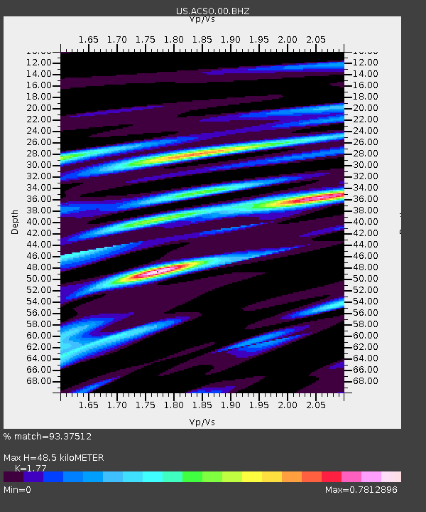
ACSO Alum Creek State Park, Ohio, USA - Earthquake Result Viewer

Earthquake location: Off East Coast Of Honshu, Japan
Earthquake latitude/longitude: 37.2/144.7
Earthquake time(UTC): 2013/10/25 (298) 17:10:19 GMT
Earthquake Depth: 35 km
Earthquake Magnitude: 7.1 MWW, 7.1 MWW, 7.1 MWB, 7.1 MWC, 7.2 MWC, 7.5 MI
Earthquake Catalog/Contributor: NEIC PDE/NEIC COMCAT
Network: US United States National Seismic Network
Station: ACSO Alum Creek State Park, Ohio, USA
Lat/Lon: 40.23 N/82.98 W
Elevation: 288 m
Distance: 91.4 deg
Az: 34.465 deg
Baz: 323.802 deg
Ray Param: 0.041597374
Estimated Moho Depth: 48.5 km
Estimated Crust Vp/Vs: 1.77
Assumed Crust Vp: 6.498 km/s
Estimated Crust Vs: 3.671 km/s
Estimated Crust Poisson's Ratio: 0.27
Radial Match: 93.37512 %
Radial Bump: 400
Transverse Match: 84.9431 %
Transverse Bump: 400
SOD ConfigId: 626651
Insert Time: 2014-04-19 06:21:40.412 +0000
GWidth: 2.5
Max Bumps: 400
Tol: 0.001

Signal To Noise

ChannelStoNSTALTA
US:ACSO:00:BHZ:20131025T17:22:51.025002Z12.68069653.1345094E-62.4718747E-7
US:ACSO:00:BH1:20131025T17:22:51.025002Z3.20506748.334662E-72.600464E-7
US:ACSO:00:BH2:20131025T17:22:51.025002Z2.52708086.1246067E-72.4235896E-7
Arrivals
Ps5.9 SECOND
PpPs20 SECOND
PsPs/PpSs26 SECOND