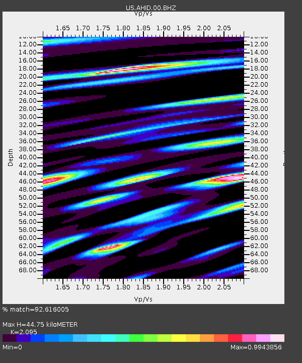
AHID Auburn Hatchery, Idaho, USA - Earthquake Result Viewer
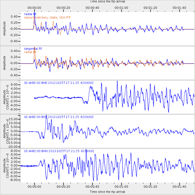
Earthquake location: Off East Coast Of Honshu, Japan
Earthquake latitude/longitude: 37.2/144.7
Earthquake time(UTC): 2013/10/25 (298) 17:10:19 GMT
Earthquake Depth: 35 km
Earthquake Magnitude: 7.1 MWW, 7.1 MWW, 7.1 MWB, 7.1 MWC, 7.2 MWC, 7.5 MI
Earthquake Catalog/Contributor: NEIC PDE/NEIC COMCAT
Network: US United States National Seismic Network
Station: AHID Auburn Hatchery, Idaho, USA
Lat/Lon: 42.77 N/111.10 W
Elevation: 1960 m
Distance: 74.8 deg
Az: 47.702 deg
Baz: 306.634 deg
Ray Param: 0.052036945
Estimated Moho Depth: 44.75 km
Estimated Crust Vp/Vs: 2.10
Assumed Crust Vp: 6.207 km/s
Estimated Crust Vs: 2.963 km/s
Estimated Crust Poisson's Ratio: 0.35
Radial Match: 92.616005 %
Radial Bump: 400
Transverse Match: 92.635445 %
Transverse Bump: 400
SOD ConfigId: 626651
Insert Time: 2014-04-19 06:21:45.844 +0000
GWidth: 2.5
Max Bumps: 400
Tol: 0.001

Signal To Noise

ChannelStoNSTALTA
US:AHID:00:BHZ:20131025T17:21:25.420999Z20.3406333.5090504E-61.7251432E-7
US:AHID:00:BHN:20131025T17:21:25.420999Z4.77231071.1267502E-62.3610161E-7
US:AHID:00:BHE:20131025T17:21:25.420999Z4.4589871.1375679E-62.5511798E-7
Arrivals
Ps8.1 SECOND
PpPs22 SECOND
PsPs/PpSs30 SECOND