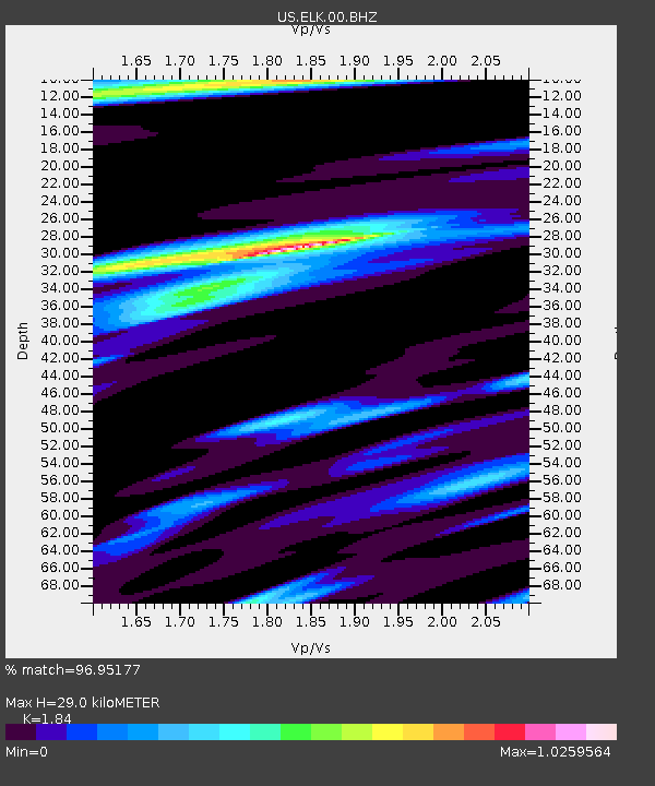
ELK Elko, Nevada, USA - Earthquake Result Viewer

Earthquake location: Off East Coast Of Honshu, Japan
Earthquake latitude/longitude: 37.2/144.7
Earthquake time(UTC): 2013/10/25 (298) 17:10:19 GMT
Earthquake Depth: 35 km
Earthquake Magnitude: 7.1 MWW, 7.1 MWW, 7.1 MWB, 7.1 MWC, 7.2 MWC, 7.5 MI
Earthquake Catalog/Contributor: NEIC PDE/NEIC COMCAT
Network: US United States National Seismic Network
Station: ELK Elko, Nevada, USA
Lat/Lon: 40.74 N/115.24 W
Elevation: 2210 m
Distance: 73.5 deg
Az: 51.285 deg
Baz: 304.867 deg
Ray Param: 0.052931923
Estimated Moho Depth: 29.0 km
Estimated Crust Vp/Vs: 1.84
Assumed Crust Vp: 6.276 km/s
Estimated Crust Vs: 3.411 km/s
Estimated Crust Poisson's Ratio: 0.29
Radial Match: 96.95177 %
Radial Bump: 400
Transverse Match: 91.83605 %
Transverse Bump: 400
SOD ConfigId: 626651
Insert Time: 2014-04-19 06:22:26.811 +0000
GWidth: 2.5
Max Bumps: 400
Tol: 0.001

Signal To Noise

ChannelStoNSTALTA
US:ELK:00:BHZ:20131025T17:21:17.650002Z38.212334.0518003E-61.06033845E-7
US:ELK:00:BH1:20131025T17:21:17.650002Z8.3778998.224168E-79.816504E-8
US:ELK:00:BH2:20131025T17:21:17.650002Z8.8851471.2982671E-61.4611656E-7
Arrivals
Ps4.0 SECOND
PpPs13 SECOND
PsPs/PpSs17 SECOND