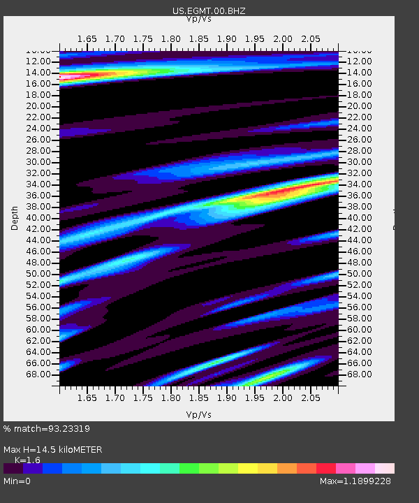
EGMT Eagleton, Montana, USA - Earthquake Result Viewer
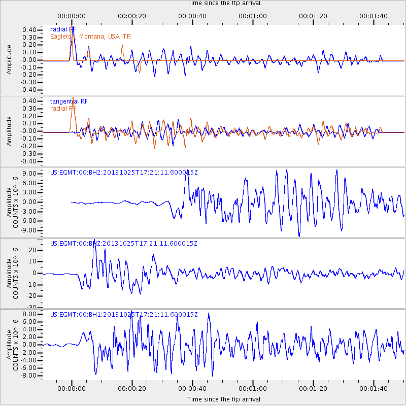
Earthquake location: Off East Coast Of Honshu, Japan
Earthquake latitude/longitude: 37.2/144.7
Earthquake time(UTC): 2013/10/25 (298) 17:10:19 GMT
Earthquake Depth: 35 km
Earthquake Magnitude: 7.1 MWW, 7.1 MWW, 7.1 MWB, 7.1 MWC, 7.2 MWC, 7.5 MI
Earthquake Catalog/Contributor: NEIC PDE/NEIC COMCAT
Network: US United States National Seismic Network
Station: EGMT Eagleton, Montana, USA
Lat/Lon: 48.02 N/109.75 W
Elevation: 1055 m
Distance: 72.4 deg
Az: 42.704 deg
Baz: 306.179 deg
Ray Param: 0.053604625
Estimated Moho Depth: 14.5 km
Estimated Crust Vp/Vs: 1.60
Assumed Crust Vp: 6.438 km/s
Estimated Crust Vs: 4.023 km/s
Estimated Crust Poisson's Ratio: 0.18
Radial Match: 93.23319 %
Radial Bump: 400
Transverse Match: 86.88268 %
Transverse Bump: 400
SOD ConfigId: 626651
Insert Time: 2014-04-19 06:22:27.013 +0000
GWidth: 2.5
Max Bumps: 400
Tol: 0.001

Signal To Noise

ChannelStoNSTALTA
US:EGMT:00:BHZ:20131025T17:21:11.600015Z34.936665.1837665E-61.4837612E-7
US:EGMT:00:BH1:20131025T17:21:11.600015Z5.2722261.5772648E-62.9916487E-7
US:EGMT:00:BH2:20131025T17:21:11.600015Z9.0893212.2253626E-62.4483262E-7
Arrivals
Ps1.4 SECOND
PpPs5.6 SECOND
PsPs/PpSs7.0 SECOND