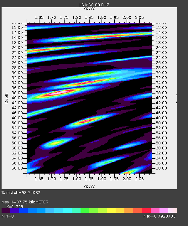
MSO Missoula, Montana, USA - Earthquake Result Viewer

Earthquake location: Off East Coast Of Honshu, Japan
Earthquake latitude/longitude: 37.2/144.7
Earthquake time(UTC): 2013/10/25 (298) 17:10:19 GMT
Earthquake Depth: 35 km
Earthquake Magnitude: 7.1 MWW, 7.1 MWW, 7.1 MWB, 7.1 MWC, 7.2 MWC, 7.5 MI
Earthquake Catalog/Contributor: NEIC PDE/NEIC COMCAT
Network: US United States National Seismic Network
Station: MSO Missoula, Montana, USA
Lat/Lon: 46.83 N/113.94 W
Elevation: 1264 m
Distance: 70.8 deg
Az: 45.456 deg
Baz: 303.973 deg
Ray Param: 0.05468671
Estimated Moho Depth: 37.75 km
Estimated Crust Vp/Vs: 1.73
Assumed Crust Vp: 6.353 km/s
Estimated Crust Vs: 3.683 km/s
Estimated Crust Poisson's Ratio: 0.25
Radial Match: 93.74082 %
Radial Bump: 400
Transverse Match: 85.55558 %
Transverse Bump: 400
SOD ConfigId: 626651
Insert Time: 2014-04-19 06:23:15.111 +0000
GWidth: 2.5
Max Bumps: 400
Tol: 0.001

Signal To Noise

ChannelStoNSTALTA
US:MSO:00:BHZ:20131025T17:21:01.775002Z29.8259074.4366866E-61.4875278E-7
US:MSO:00:BH1:20131025T17:21:01.775002Z7.0839691.1125301E-61.5704897E-7
US:MSO:00:BH2:20131025T17:21:01.775002Z8.2339661.6123495E-61.9581688E-7
Arrivals
Ps4.5 SECOND
PpPs16 SECOND
PsPs/PpSs20 SECOND