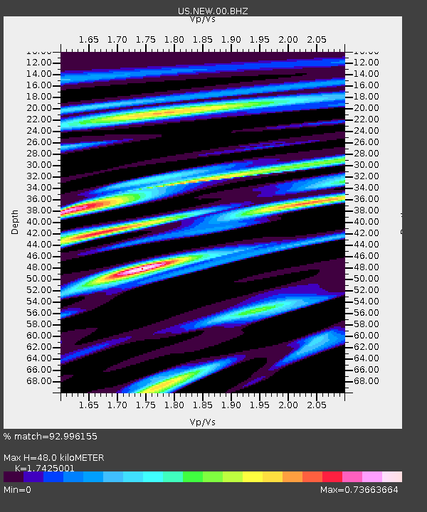
NEW Newport, Washington, USA - Earthquake Result Viewer
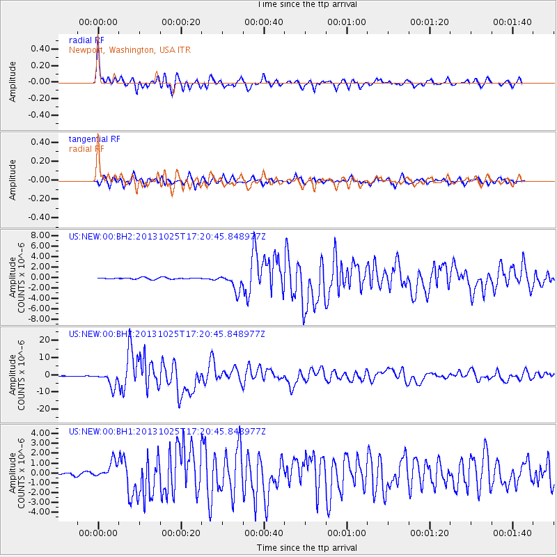
Earthquake location: Off East Coast Of Honshu, Japan
Earthquake latitude/longitude: 37.2/144.7
Earthquake time(UTC): 2013/10/25 (298) 17:10:19 GMT
Earthquake Depth: 35 km
Earthquake Magnitude: 7.1 MWW, 7.1 MWW, 7.1 MWB, 7.1 MWC, 7.2 MWC, 7.5 MI
Earthquake Catalog/Contributor: NEIC PDE/NEIC COMCAT
Network: US United States National Seismic Network
Station: NEW Newport, Washington, USA
Lat/Lon: 48.26 N/117.12 W
Elevation: 760 m
Distance: 68.2 deg
Az: 45.414 deg
Baz: 301.619 deg
Ray Param: 0.05639399
Estimated Moho Depth: 48.0 km
Estimated Crust Vp/Vs: 1.74
Assumed Crust Vp: 6.571 km/s
Estimated Crust Vs: 3.771 km/s
Estimated Crust Poisson's Ratio: 0.25
Radial Match: 92.996155 %
Radial Bump: 400
Transverse Match: 88.472786 %
Transverse Bump: 400
SOD ConfigId: 626651
Insert Time: 2014-04-19 06:23:24.726 +0000
GWidth: 2.5
Max Bumps: 400
Tol: 0.001

Signal To Noise

ChannelStoNSTALTA
US:NEW:00:BHZ:20131025T17:20:45.848977Z39.5011524.5439556E-61.150335E-7
US:NEW:00:BH1:20131025T17:20:45.848977Z9.0603639.0339535E-79.9708515E-8
US:NEW:00:BH2:20131025T17:20:45.848977Z11.4857491.7135892E-61.4919263E-7
Arrivals
Ps5.7 SECOND
PpPs19 SECOND
PsPs/PpSs25 SECOND