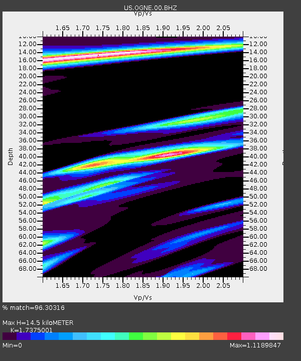
OGNE Ogallala, Nebraska, USA - Earthquake Result Viewer
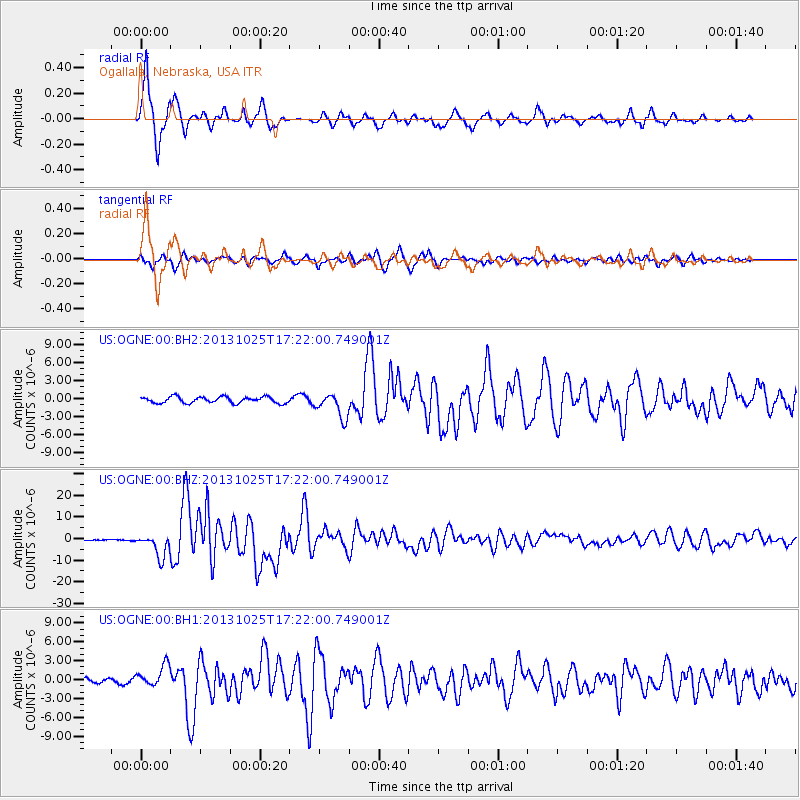
Earthquake location: Off East Coast Of Honshu, Japan
Earthquake latitude/longitude: 37.2/144.7
Earthquake time(UTC): 2013/10/25 (298) 17:10:19 GMT
Earthquake Depth: 35 km
Earthquake Magnitude: 7.1 MWW, 7.1 MWW, 7.1 MWB, 7.1 MWC, 7.2 MWC, 7.5 MI
Earthquake Catalog/Contributor: NEIC PDE/NEIC COMCAT
Network: US United States National Seismic Network
Station: OGNE Ogallala, Nebraska, USA
Lat/Lon: 40.95 N/102.03 W
Elevation: 0.0 m
Distance: 81.2 deg
Az: 44.75 deg
Baz: 312.054 deg
Ray Param: 0.0477117
Estimated Moho Depth: 14.5 km
Estimated Crust Vp/Vs: 1.74
Assumed Crust Vp: 6.483 km/s
Estimated Crust Vs: 3.731 km/s
Estimated Crust Poisson's Ratio: 0.25
Radial Match: 96.30316 %
Radial Bump: 364
Transverse Match: 89.438324 %
Transverse Bump: 400
SOD ConfigId: 626651
Insert Time: 2014-04-19 06:23:29.305 +0000
GWidth: 2.5
Max Bumps: 400
Tol: 0.001

Signal To Noise

ChannelStoNSTALTA
US:OGNE:00:BHZ:20131025T17:22:00.749001Z19.8140985.3266863E-62.6883313E-7
US:OGNE:00:BH1:20131025T17:22:00.749001Z3.89588741.7447903E-64.478544E-7
US:OGNE:00:BH2:20131025T17:22:00.749001Z4.0064582.0772636E-65.184789E-7
Arrivals
Ps1.7 SECOND
PpPs6.0 SECOND
PsPs/PpSs7.6 SECOND