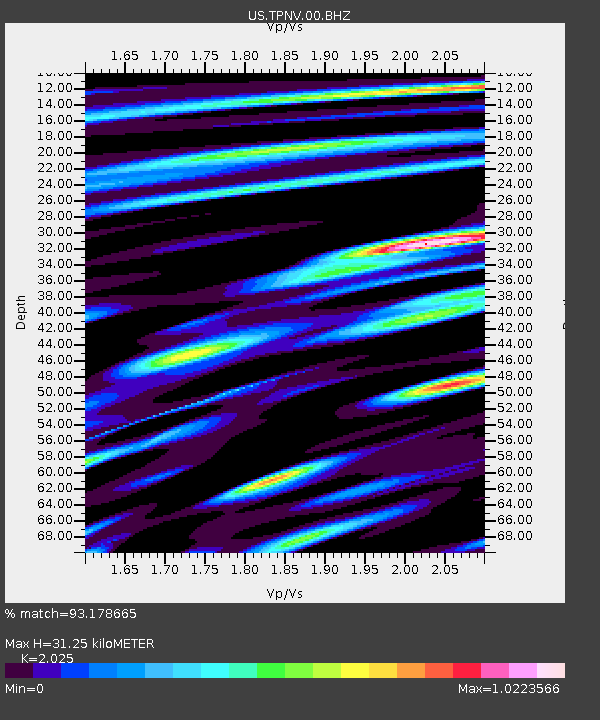
TPNV Topopah Spring, Nevada, USA - Earthquake Result Viewer
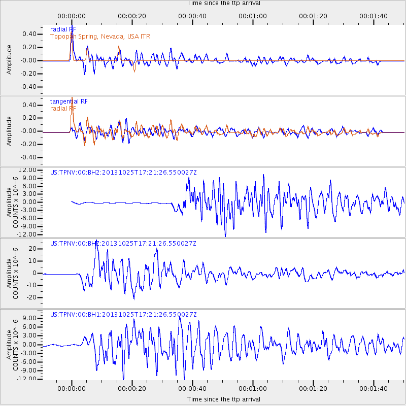
Earthquake location: Off East Coast Of Honshu, Japan
Earthquake latitude/longitude: 37.2/144.7
Earthquake time(UTC): 2013/10/25 (298) 17:10:19 GMT
Earthquake Depth: 35 km
Earthquake Magnitude: 7.1 MWW, 7.1 MWW, 7.1 MWB, 7.1 MWC, 7.2 MWC, 7.5 MI
Earthquake Catalog/Contributor: NEIC PDE/NEIC COMCAT
Network: US United States National Seismic Network
Station: TPNV Topopah Spring, Nevada, USA
Lat/Lon: 36.95 N/116.25 W
Elevation: 1600 m
Distance: 75.0 deg
Az: 54.981 deg
Baz: 305.24 deg
Ray Param: 0.051907863
Estimated Moho Depth: 31.25 km
Estimated Crust Vp/Vs: 2.03
Assumed Crust Vp: 6.279 km/s
Estimated Crust Vs: 3.101 km/s
Estimated Crust Poisson's Ratio: 0.34
Radial Match: 93.178665 %
Radial Bump: 400
Transverse Match: 92.58932 %
Transverse Bump: 400
SOD ConfigId: 626651
Insert Time: 2014-04-19 06:23:44.601 +0000
GWidth: 2.5
Max Bumps: 400
Tol: 0.001

Signal To Noise

ChannelStoNSTALTA
US:TPNV:00:BHZ:20131025T17:21:26.550027Z33.784454.9927116E-61.4778135E-7
US:TPNV:00:BH1:20131025T17:21:26.550027Z5.8862451.1283176E-61.9168718E-7
US:TPNV:00:BH2:20131025T17:21:26.550027Z8.0607611.3225093E-61.6406754E-7
Arrivals
Ps5.2 SECOND
PpPs15 SECOND
PsPs/PpSs20 SECOND