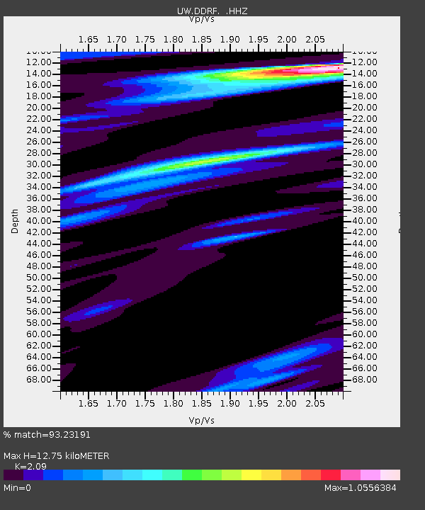
DDRF Dider Farm, Eltopia, WA, USA - Earthquake Result Viewer

Earthquake location: Off East Coast Of Honshu, Japan
Earthquake latitude/longitude: 37.2/144.7
Earthquake time(UTC): 2013/10/25 (298) 17:10:19 GMT
Earthquake Depth: 35 km
Earthquake Magnitude: 7.1 MWW, 7.1 MWW, 7.1 MWB, 7.1 MWC, 7.2 MWC, 7.5 MI
Earthquake Catalog/Contributor: NEIC PDE/NEIC COMCAT
Network: UW Pacific Northwest Regional Seismic Network
Station: DDRF Dider Farm, Eltopia, WA, USA
Lat/Lon: 46.49 N/119.06 W
Elevation: 233 m
Distance: 68.0 deg
Az: 47.784 deg
Baz: 301.08 deg
Ray Param: 0.05652682
Estimated Moho Depth: 12.75 km
Estimated Crust Vp/Vs: 2.09
Assumed Crust Vp: 6.419 km/s
Estimated Crust Vs: 3.071 km/s
Estimated Crust Poisson's Ratio: 0.35
Radial Match: 93.23191 %
Radial Bump: 400
Transverse Match: 69.68248 %
Transverse Bump: 400
SOD ConfigId: 626651
Insert Time: 2014-04-19 06:25:17.587 +0000
GWidth: 2.5
Max Bumps: 400
Tol: 0.001

Signal To Noise

ChannelStoNSTALTA
UW:DDRF: :HHZ:20131025T17:20:44.567971Z20.2855555.312631E-62.6189232E-7
UW:DDRF: :HHN:20131025T17:20:44.567971Z8.46571.0056791E-61.1879457E-7
UW:DDRF: :HHE:20131025T17:20:44.567971Z13.0957961.8234831E-61.3924186E-7
Arrivals
Ps2.2 SECOND
PpPs5.9 SECOND
PsPs/PpSs8.2 SECOND