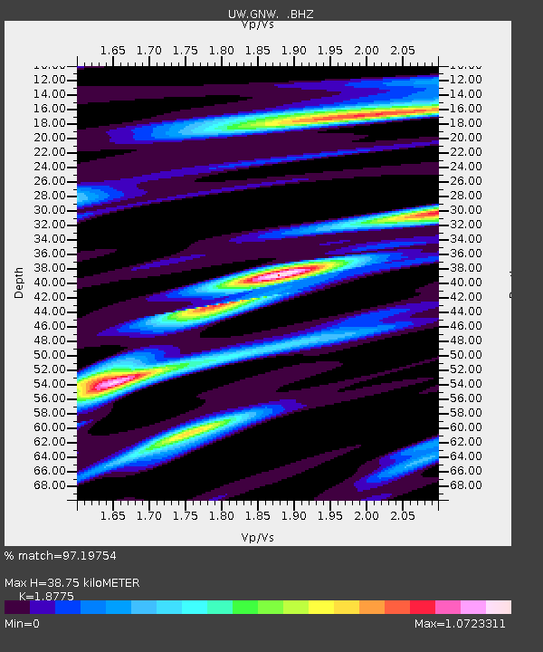
GNW Green Mountain (BB) - Earthquake Result Viewer

Earthquake location: Off East Coast Of Honshu, Japan
Earthquake latitude/longitude: 37.2/144.7
Earthquake time(UTC): 2013/10/25 (298) 17:10:19 GMT
Earthquake Depth: 35 km
Earthquake Magnitude: 7.1 MWW, 7.1 MWW, 7.1 MWB, 7.1 MWC, 7.2 MWC, 7.5 MI
Earthquake Catalog/Contributor: NEIC PDE/NEIC COMCAT
Network: UW Pacific Northwest Regional Seismic Network
Station: GNW Green Mountain (BB)
Lat/Lon: 47.56 N/122.83 W
Elevation: 160 m
Distance: 65.2 deg
Az: 48.163 deg
Baz: 298.483 deg
Ray Param: 0.058341883
Estimated Moho Depth: 38.75 km
Estimated Crust Vp/Vs: 1.88
Assumed Crust Vp: 6.566 km/s
Estimated Crust Vs: 3.497 km/s
Estimated Crust Poisson's Ratio: 0.30
Radial Match: 97.19754 %
Radial Bump: 372
Transverse Match: 95.66358 %
Transverse Bump: 400
SOD ConfigId: 626651
Insert Time: 2014-04-19 06:25:23.773 +0000
GWidth: 2.5
Max Bumps: 400
Tol: 0.001

Signal To Noise

ChannelStoNSTALTA
UW:GNW: :BHZ:20131025T17:20:26.965005Z49.0969285.6650692E-61.1538541E-7
UW:GNW: :BHN:20131025T17:20:26.965005Z2.29702524.0336204E-71.7560193E-7
UW:GNW: :BHE:20131025T17:20:26.965005Z11.9571911.9661015E-61.6442836E-7
Arrivals
Ps5.4 SECOND
PpPs16 SECOND
PsPs/PpSs22 SECOND