You are here: Home > Network List > TA - USArray Transportable Network (new EarthScope stations) Stations List
> Station MSTX Muleshoe, TX, USA > Earthquake Result Viewer
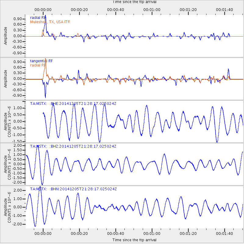
MSTX Muleshoe, TX, USA - Earthquake Result Viewer
*The percent match for this event was below the threshold and hence no stack was calculated.
| Earthquake location: |
Vanuatu Islands |
| Earthquake latitude/longitude: |
-13.4/166.3 |
| Earthquake time(UTC): |
2014/12/05 (339) 21:15:15 GMT |
| Earthquake Depth: |
36 km |
| Earthquake Magnitude: |
5.0 MW, 5.3 mb |
| Earthquake Catalog/Contributor: |
ISC/ISC |
|
| Network: |
TA USArray Transportable Network (new EarthScope stations) |
| Station: |
MSTX Muleshoe, TX, USA |
| Lat/Lon: |
33.97 N/102.77 W |
| Elevation: |
1167 m |
|
| Distance: |
98.1 deg |
| Az: |
57.073 deg |
| Baz: |
259.43 deg |
| Ray Param: |
$rayparam |
*The percent match for this event was below the threshold and hence was not used in the summary stack. |
|
| Radial Match: |
68.01791 % |
| Radial Bump: |
400 |
| Transverse Match: |
62.84581 % |
| Transverse Bump: |
396 |
| SOD ConfigId: |
3390531 |
| Insert Time: |
2019-04-15 09:07:05.877 +0000 |
| GWidth: |
2.5 |
| Max Bumps: |
400 |
| Tol: |
0.001 |
|
Signal To Noise
| Channel | StoN | STA | LTA |
| TA:MSTX: :BHZ:20141205T21:28:17.025024Z | 2.2675037 | 1.2761931E-6 | 5.628185E-7 |
| TA:MSTX: :BHN:20141205T21:28:17.025024Z | 1.3019181 | 1.168261E-6 | 8.973383E-7 |
| TA:MSTX: :BHE:20141205T21:28:17.025024Z | 1.2509183 | 9.968959E-7 | 7.969313E-7 |
| Arrivals |
| Ps | |
| PpPs | |
| PsPs/PpSs | |


