LTY Liberty (broad-band) - Earthquake Result Viewer
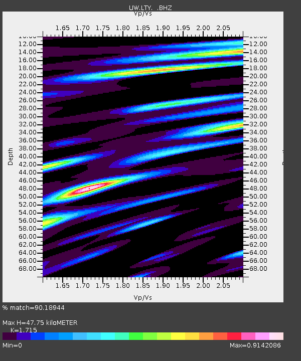
Earthquake location: Off East Coast Of Honshu, Japan
Earthquake latitude/longitude: 37.2/144.7
Earthquake time(UTC): 2013/10/25 (298) 17:10:19 GMT
Earthquake Depth: 35 km
Earthquake Magnitude: 7.1 MWW, 7.1 MWW, 7.1 MWB, 7.1 MWC, 7.2 MWC, 7.5 MI
Earthquake Catalog/Contributor: NEIC PDE/NEIC COMCAT
Network: UW Pacific Northwest Regional Seismic Network
Station: LTY Liberty (broad-band)
Lat/Lon: 47.26 N/120.66 W
Elevation: 970 m
Distance: 66.7 deg
Az: 47.675 deg
Baz: 299.87 deg
Ray Param: 0.05740153
Estimated Moho Depth: 47.75 km
Estimated Crust Vp/Vs: 1.72
Assumed Crust Vp: 6.597 km/s
Estimated Crust Vs: 3.847 km/s
Estimated Crust Poisson's Ratio: 0.24
Radial Match: 90.18944 %
Radial Bump: 400
Transverse Match: 86.97899 %
Transverse Bump: 400
SOD ConfigId: 626651
Insert Time: 2014-04-19 06:25:50.312 +0000
GWidth: 2.5
Max Bumps: 400
Tol: 0.001

Signal To Noise

ChannelStoNSTALTA
UW:LTY: :BHZ:20131025T17:20:36.129983Z25.5117995.2963487E-62.0760389E-7
UW:LTY: :BHN:20131025T17:20:36.129983Z18.4342381.7007607E-69.226096E-8
UW:LTY: :BHE:20131025T17:20:36.129983Z9.1365351.4433358E-61.579741E-7
Arrivals
Ps5.4 SECOND
PpPs19 SECOND
PsPs/PpSs24 SECOND