MRBL Marblemount, WA, USA - Earthquake Result Viewer
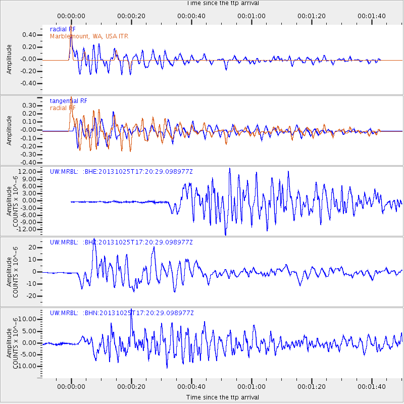
Earthquake location: Off East Coast Of Honshu, Japan
Earthquake latitude/longitude: 37.2/144.7
Earthquake time(UTC): 2013/10/25 (298) 17:10:19 GMT
Earthquake Depth: 35 km
Earthquake Magnitude: 7.1 MWW, 7.1 MWW, 7.1 MWB, 7.1 MWC, 7.2 MWC, 7.5 MI
Earthquake Catalog/Contributor: NEIC PDE/NEIC COMCAT
Network: UW Pacific Northwest Regional Seismic Network
Station: MRBL Marblemount, WA, USA
Lat/Lon: 48.52 N/121.48 W
Elevation: 75 m
Distance: 65.6 deg
Az: 46.768 deg
Baz: 298.896 deg
Ray Param: 0.05812468
Estimated Moho Depth: 39.5 km
Estimated Crust Vp/Vs: 1.69
Assumed Crust Vp: 6.566 km/s
Estimated Crust Vs: 3.885 km/s
Estimated Crust Poisson's Ratio: 0.23
Radial Match: 91.20767 %
Radial Bump: 400
Transverse Match: 84.32822 %
Transverse Bump: 400
SOD ConfigId: 626651
Insert Time: 2014-04-19 06:25:52.282 +0000
GWidth: 2.5
Max Bumps: 400
Tol: 0.001

Signal To Noise

ChannelStoNSTALTA
UW:MRBL: :BHZ:20131025T17:20:29.098977Z36.681325.045229E-61.3754217E-7
UW:MRBL: :BHN:20131025T17:20:29.098977Z6.4379341.3234269E-62.05567E-7
UW:MRBL: :BHE:20131025T17:20:29.098977Z12.7165141.8701812E-61.4706714E-7
Arrivals
Ps4.3 SECOND
PpPs15 SECOND
PsPs/PpSs20 SECOND