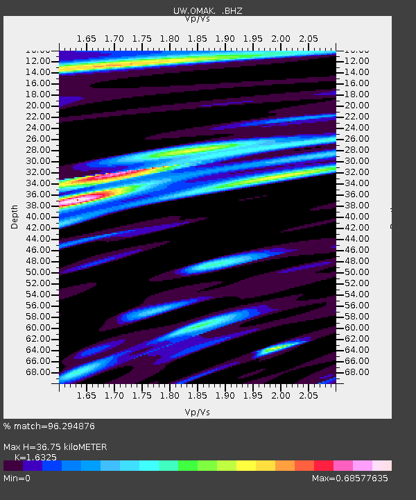
OMAK Colville Reservation, Omak, WA, USA - Earthquake Result Viewer
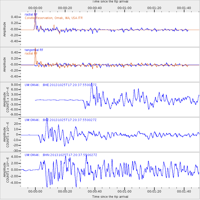
Earthquake location: Off East Coast Of Honshu, Japan
Earthquake latitude/longitude: 37.2/144.7
Earthquake time(UTC): 2013/10/25 (298) 17:10:19 GMT
Earthquake Depth: 35 km
Earthquake Magnitude: 7.1 MWW, 7.1 MWW, 7.1 MWB, 7.1 MWC, 7.2 MWC, 7.5 MI
Earthquake Catalog/Contributor: NEIC PDE/NEIC COMCAT
Network: UW Pacific Northwest Regional Seismic Network
Station: OMAK Colville Reservation, Omak, WA, USA
Lat/Lon: 48.36 N/119.33 W
Elevation: 696 m
Distance: 66.9 deg
Az: 46.147 deg
Baz: 300.251 deg
Ray Param: 0.05725217
Estimated Moho Depth: 36.75 km
Estimated Crust Vp/Vs: 1.63
Assumed Crust Vp: 6.419 km/s
Estimated Crust Vs: 3.932 km/s
Estimated Crust Poisson's Ratio: 0.20
Radial Match: 96.294876 %
Radial Bump: 400
Transverse Match: 91.665146 %
Transverse Bump: 400
SOD ConfigId: 626651
Insert Time: 2014-04-19 06:25:54.656 +0000
GWidth: 2.5
Max Bumps: 400
Tol: 0.001

Signal To Noise

ChannelStoNSTALTA
UW:OMAK: :BHZ:20131025T17:20:37.550027Z41.268175.4912316E-61.3306216E-7
UW:OMAK: :BHN:20131025T17:20:37.550027Z6.8492969.916366E-71.4477935E-7
UW:OMAK: :BHE:20131025T17:20:37.550027Z18.7160112.037367E-61.088569E-7
Arrivals
Ps3.8 SECOND
PpPs14 SECOND
PsPs/PpSs18 SECOND