You are here: Home > Network List > UW - Pacific Northwest Regional Seismic Network Stations List
> Station MRBL Marblemount, WA, USA > Earthquake Result Viewer
MRBL Marblemount, WA, USA - Earthquake Result Viewer
*The percent match for this event was below the threshold and hence no stack was calculated.
| Earthquake location: |
Vanuatu Islands |
| Earthquake latitude/longitude: |
-13.4/166.3 |
| Earthquake time(UTC): |
2014/12/05 (339) 21:15:15 GMT |
| Earthquake Depth: |
36 km |
| Earthquake Magnitude: |
5.0 MW, 5.3 mb |
| Earthquake Catalog/Contributor: |
ISC/ISC |
|
| Network: |
UW Pacific Northwest Regional Seismic Network |
| Station: |
MRBL Marblemount, WA, USA |
| Lat/Lon: |
48.52 N/121.48 W |
| Elevation: |
75 m |
|
| Distance: |
88.5 deg |
| Az: |
39.305 deg |
| Baz: |
248.018 deg |
| Ray Param: |
$rayparam |
*The percent match for this event was below the threshold and hence was not used in the summary stack. |
|
| Radial Match: |
81.477325 % |
| Radial Bump: |
400 |
| Transverse Match: |
59.4997 % |
| Transverse Bump: |
400 |
| SOD ConfigId: |
3390531 |
| Insert Time: |
2019-04-15 09:07:41.178 +0000 |
| GWidth: |
2.5 |
| Max Bumps: |
400 |
| Tol: |
0.001 |
|
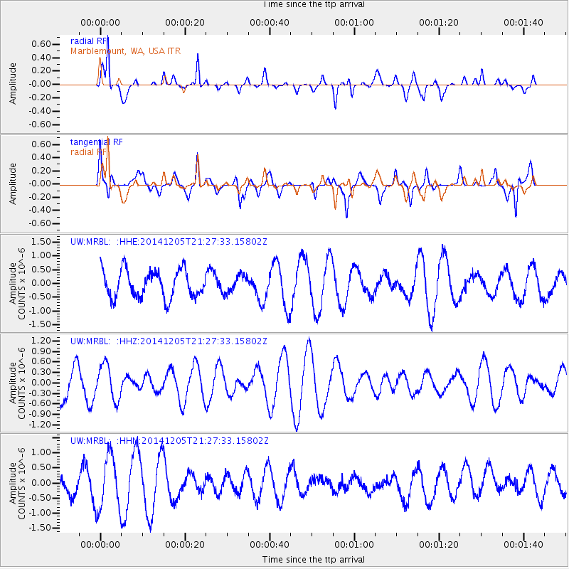
Signal To Noise
| Channel | StoN | STA | LTA |
| UW:MRBL: :HHZ:20141205T21:27:33.15802Z | 1.1378205 | 5.068937E-7 | 4.4549535E-7 |
| UW:MRBL: :HHN:20141205T21:27:33.15802Z | 1.7555481 | 9.0653555E-7 | 5.1638324E-7 |
| UW:MRBL: :HHE:20141205T21:27:33.15802Z | 0.6333577 | 3.1240813E-7 | 4.93257E-7 |
| Arrivals |
| Ps | |
| PpPs | |
| PsPs/PpSs | |


