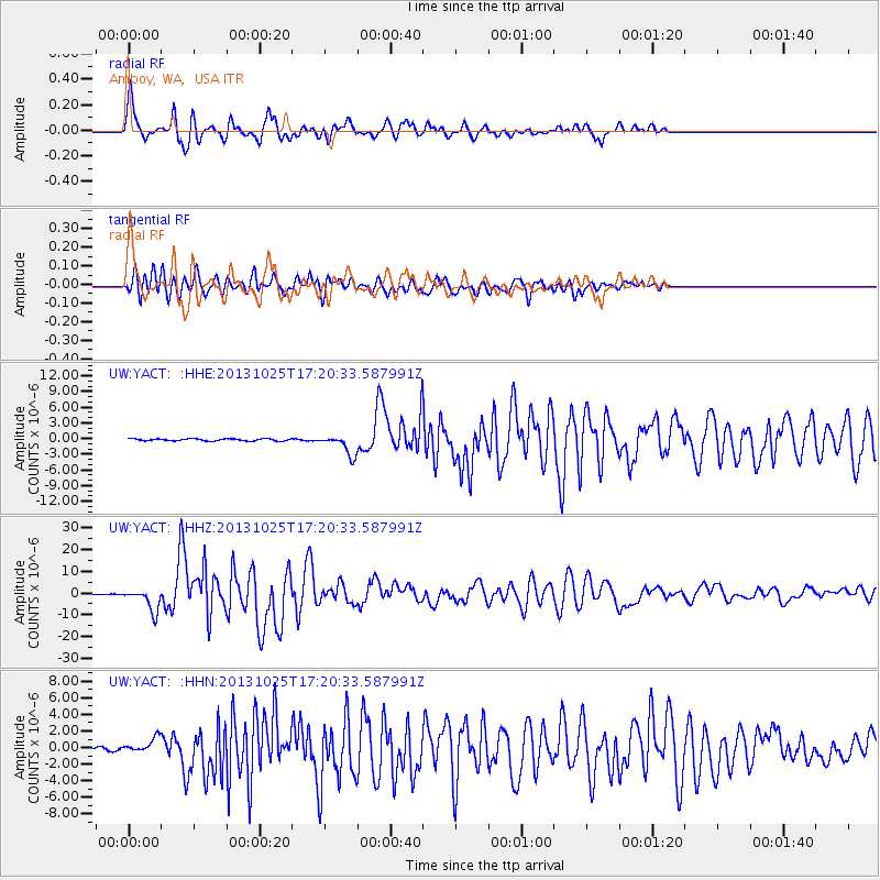
YACT Amboy, WA, USA - Earthquake Result Viewer
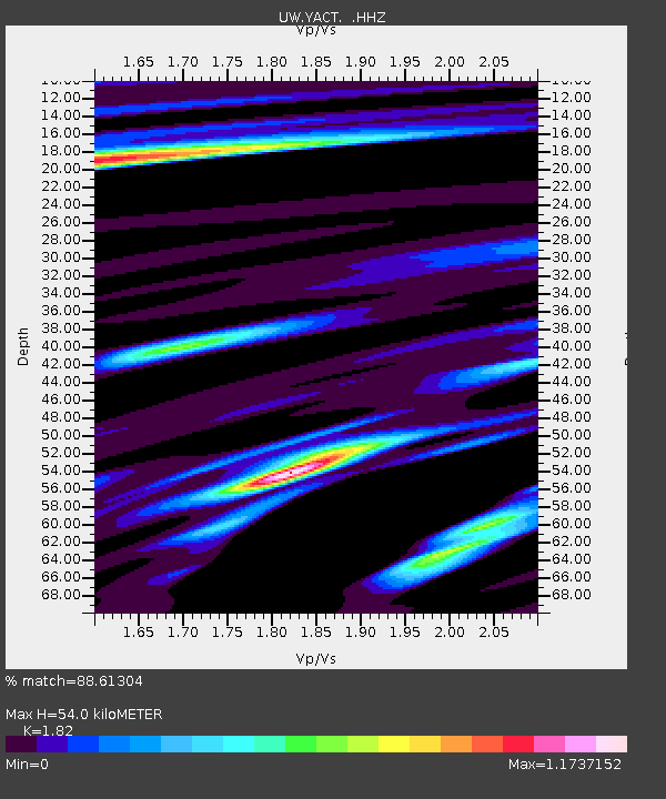
Earthquake location: Off East Coast Of Honshu, Japan
Earthquake latitude/longitude: 37.2/144.7
Earthquake time(UTC): 2013/10/25 (298) 17:10:19 GMT
Earthquake Depth: 35 km
Earthquake Magnitude: 7.1 MWW, 7.1 MWW, 7.1 MWB, 7.1 MWC, 7.2 MWC, 7.5 MI
Earthquake Catalog/Contributor: NEIC PDE/NEIC COMCAT
Network: UW Pacific Northwest Regional Seismic Network
Station: YACT Amboy, WA, USA
Lat/Lon: 45.93 N/122.42 W
Elevation: 211 m
Distance: 66.3 deg
Az: 49.582 deg
Baz: 299.361 deg
Ray Param: 0.0576647
Estimated Moho Depth: 54.0 km
Estimated Crust Vp/Vs: 1.82
Assumed Crust Vp: 6.566 km/s
Estimated Crust Vs: 3.608 km/s
Estimated Crust Poisson's Ratio: 0.28
Radial Match: 88.61304 %
Radial Bump: 400
Transverse Match: 82.239494 %
Transverse Bump: 400
SOD ConfigId: 626651
Insert Time: 2014-04-19 06:26:24.342 +0000
GWidth: 2.5
Max Bumps: 400
Tol: 0.001

Signal To Noise

ChannelStoNSTALTA
UW:YACT: :HHZ:20131025T17:20:33.587991Z24.868025.2625996E-62.1162118E-7
UW:YACT: :HHN:20131025T17:20:33.587991Z8.4974498.76722E-71.03174735E-7
UW:YACT: :HHE:20131025T17:20:33.587991Z9.9107591.9405982E-61.9580723E-7
Arrivals
Ps7.0 SECOND
PpPs22 SECOND
PsPs/PpSs29 SECOND