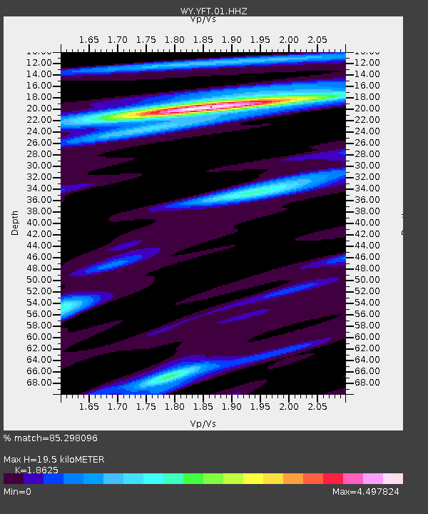
YFT Old Faithful, YNP, WY, USA - Earthquake Result Viewer

Earthquake location: Off East Coast Of Honshu, Japan
Earthquake latitude/longitude: 37.2/144.7
Earthquake time(UTC): 2013/10/25 (298) 17:10:19 GMT
Earthquake Depth: 35 km
Earthquake Magnitude: 7.1 MWW, 7.1 MWW, 7.1 MWB, 7.1 MWC, 7.2 MWC, 7.5 MI
Earthquake Catalog/Contributor: NEIC PDE/NEIC COMCAT
Network: WY Yellowstone Wyoming Seismic Network
Station: YFT Old Faithful, YNP, WY, USA
Lat/Lon: 44.45 N/110.84 W
Elevation: 2292 m
Distance: 74.0 deg
Az: 46.177 deg
Baz: 306.405 deg
Ray Param: 0.052606788
Estimated Moho Depth: 19.5 km
Estimated Crust Vp/Vs: 1.86
Assumed Crust Vp: 6.35 km/s
Estimated Crust Vs: 3.409 km/s
Estimated Crust Poisson's Ratio: 0.30
Radial Match: 85.298096 %
Radial Bump: 400
Transverse Match: 87.11521 %
Transverse Bump: 400
SOD ConfigId: 626651
Insert Time: 2014-04-19 06:27:28.655 +0000
GWidth: 2.5
Max Bumps: 400
Tol: 0.001

Signal To Noise

ChannelStoNSTALTA
WY:YFT:01:HHZ:20131025T17:21:20.490029Z3.12829692.3875245E-87.6320275E-9
WY:YFT:01:HHN:20131025T17:21:20.490029Z1.91322748.294262E-94.33522E-9
WY:YFT:01:HHE:20131025T17:21:20.490029Z1.24565067.973E-96.4006707E-9
Arrivals
Ps2.7 SECOND
PpPs8.5 SECOND
PsPs/PpSs11 SECOND