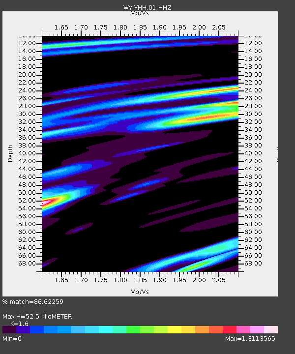
YHH Holmes Hill, YNP, WY, USA - Earthquake Result Viewer
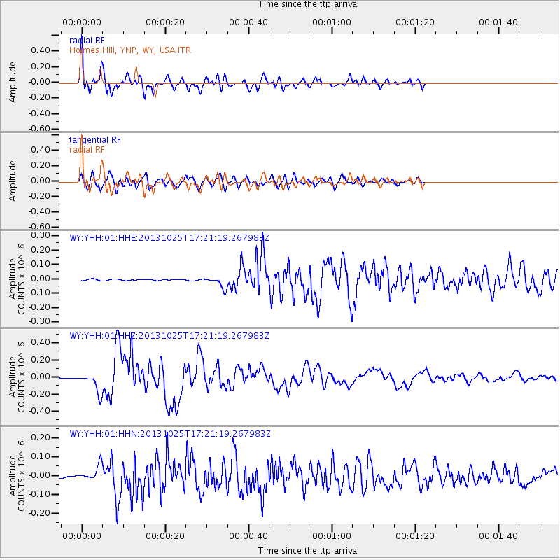
Earthquake location: Off East Coast Of Honshu, Japan
Earthquake latitude/longitude: 37.2/144.7
Earthquake time(UTC): 2013/10/25 (298) 17:10:19 GMT
Earthquake Depth: 35 km
Earthquake Magnitude: 7.1 MWW, 7.1 MWW, 7.1 MWB, 7.1 MWC, 7.2 MWC, 7.5 MI
Earthquake Catalog/Contributor: NEIC PDE/NEIC COMCAT
Network: WY Yellowstone Wyoming Seismic Network
Station: YHH Holmes Hill, YNP, WY, USA
Lat/Lon: 44.79 N/110.85 W
Elevation: 2717 m
Distance: 73.7 deg
Az: 45.901 deg
Baz: 306.318 deg
Ray Param: 0.052746616
Estimated Moho Depth: 52.5 km
Estimated Crust Vp/Vs: 1.60
Assumed Crust Vp: 6.35 km/s
Estimated Crust Vs: 3.969 km/s
Estimated Crust Poisson's Ratio: 0.18
Radial Match: 86.62259 %
Radial Bump: 400
Transverse Match: 75.63914 %
Transverse Bump: 400
SOD ConfigId: 626651
Insert Time: 2014-04-19 06:27:39.222 +0000
GWidth: 2.5
Max Bumps: 400
Tol: 0.001

Signal To Noise

ChannelStoNSTALTA
WY:YHH:01:HHZ:20131025T17:21:19.267983Z34.4385721.1931316E-73.4645211E-9
WY:YHH:01:HHN:20131025T17:21:19.267983Z5.4598674.1295184E-87.563404E-9
WY:YHH:01:HHE:20131025T17:21:19.267983Z9.4387264.0690427E-84.3110084E-9
Arrivals
Ps5.1 SECOND
PpPs21 SECOND
PsPs/PpSs26 SECOND