YUF Upper Falls, WY, USA - Earthquake Result Viewer
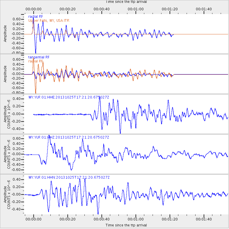
Earthquake location: Off East Coast Of Honshu, Japan
Earthquake latitude/longitude: 37.2/144.7
Earthquake time(UTC): 2013/10/25 (298) 17:10:19 GMT
Earthquake Depth: 35 km
Earthquake Magnitude: 7.1 MWW, 7.1 MWW, 7.1 MWB, 7.1 MWC, 7.2 MWC, 7.5 MI
Earthquake Catalog/Contributor: NEIC PDE/NEIC COMCAT
Network: WY Yellowstone Wyoming Seismic Network
Station: YUF Upper Falls, WY, USA
Lat/Lon: 44.71 N/110.51 W
Elevation: 2394 m
Distance: 74.0 deg
Az: 45.815 deg
Baz: 306.531 deg
Ray Param: 0.052585974
Estimated Moho Depth: 47.5 km
Estimated Crust Vp/Vs: 1.66
Assumed Crust Vp: 6.35 km/s
Estimated Crust Vs: 3.825 km/s
Estimated Crust Poisson's Ratio: 0.22
Radial Match: 88.59965 %
Radial Bump: 400
Transverse Match: 71.17934 %
Transverse Bump: 400
SOD ConfigId: 626651
Insert Time: 2014-04-19 06:28:20.794 +0000
GWidth: 2.5
Max Bumps: 400
Tol: 0.001

Signal To Noise

ChannelStoNSTALTA
WY:YUF:01:HHZ:20131025T17:21:20.675027Z22.5527231.1544192E-75.1187574E-9
WY:YUF:01:HHN:20131025T17:21:20.675027Z4.5053074.5927248E-81.0194032E-8
WY:YUF:01:HHE:20131025T17:21:20.675027Z8.0936184.527231E-85.5935807E-9
Arrivals
Ps5.1 SECOND
PpPs19 SECOND
PsPs/PpSs24 SECOND