You are here: Home > Network List > US - United States National Seismic Network Stations List
> Station HAWA Hanford, Washington, USA > Earthquake Result Viewer
HAWA Hanford, Washington, USA - Earthquake Result Viewer
*The percent match for this event was below the threshold and hence no stack was calculated.
| Earthquake location: |
Tonga Islands |
| Earthquake latitude/longitude: |
-19.4/-173.7 |
| Earthquake time(UTC): |
2013/10/25 (298) 17:54:31 GMT |
| Earthquake Depth: |
8.7 km |
| Earthquake Magnitude: |
5.7 MB |
| Earthquake Catalog/Contributor: |
NEIC PDE/NEIC COMCAT |
|
| Network: |
US United States National Seismic Network |
| Station: |
HAWA Hanford, Washington, USA |
| Lat/Lon: |
46.39 N/119.53 W |
| Elevation: |
364 m |
|
| Distance: |
81.7 deg |
| Az: |
34.561 deg |
| Baz: |
230.699 deg |
| Ray Param: |
$rayparam |
*The percent match for this event was below the threshold and hence was not used in the summary stack. |
|
| Radial Match: |
82.46871 % |
| Radial Bump: |
370 |
| Transverse Match: |
90.23197 % |
| Transverse Bump: |
363 |
| SOD ConfigId: |
626651 |
| Insert Time: |
2014-04-19 06:42:54.201 +0000 |
| GWidth: |
2.5 |
| Max Bumps: |
400 |
| Tol: |
0.001 |
|
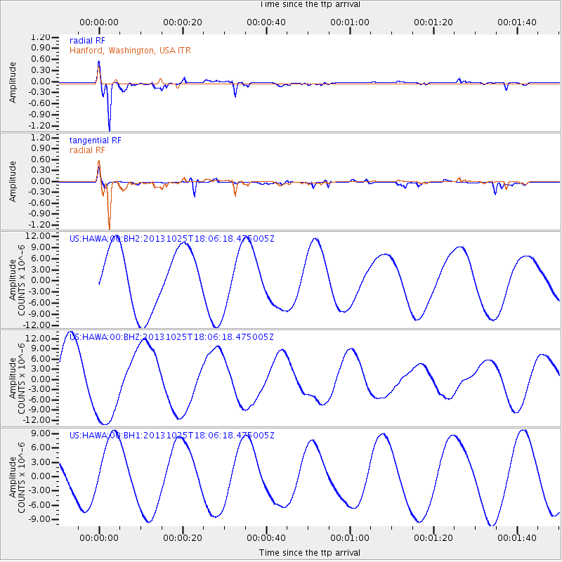
Signal To Noise
| Channel | StoN | STA | LTA |
| US:HAWA:00:BHZ:20131025T18:06:18.475005Z | 1.7936026 | 1.2216654E-5 | 6.811238E-6 |
| US:HAWA:00:BH1:20131025T18:06:18.475005Z | 1.5079097 | 6.7310857E-6 | 4.463852E-6 |
| US:HAWA:00:BH2:20131025T18:06:18.475005Z | 0.9939427 | 7.8230005E-6 | 7.870675E-6 |
| Arrivals |
| Ps | |
| PpPs | |
| PsPs/PpSs | |


