You are here: Home > Network List > UW - Pacific Northwest Regional Seismic Network Stations List
> Station MRBL Marblemount, WA, USA > Earthquake Result Viewer
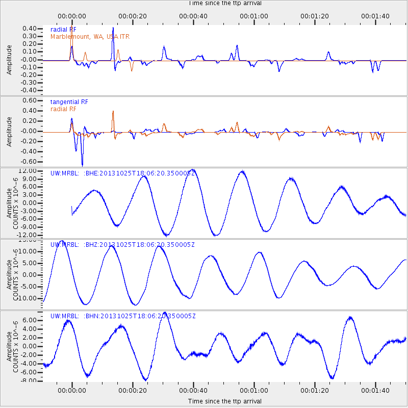
MRBL Marblemount, WA, USA - Earthquake Result Viewer
*The percent match for this event was below the threshold and hence no stack was calculated.
| Earthquake location: |
Tonga Islands |
| Earthquake latitude/longitude: |
-19.4/-173.7 |
| Earthquake time(UTC): |
2013/10/25 (298) 17:54:31 GMT |
| Earthquake Depth: |
8.7 km |
| Earthquake Magnitude: |
5.7 MB |
| Earthquake Catalog/Contributor: |
NEIC PDE/NEIC COMCAT |
|
| Network: |
UW Pacific Northwest Regional Seismic Network |
| Station: |
MRBL Marblemount, WA, USA |
| Lat/Lon: |
48.52 N/121.48 W |
| Elevation: |
75 m |
|
| Distance: |
82.1 deg |
| Az: |
32.057 deg |
| Baz: |
228.911 deg |
| Ray Param: |
$rayparam |
*The percent match for this event was below the threshold and hence was not used in the summary stack. |
|
| Radial Match: |
90.4448 % |
| Radial Bump: |
316 |
| Transverse Match: |
93.86186 % |
| Transverse Bump: |
301 |
| SOD ConfigId: |
626651 |
| Insert Time: |
2014-04-19 06:43:57.464 +0000 |
| GWidth: |
2.5 |
| Max Bumps: |
400 |
| Tol: |
0.001 |
|
Signal To Noise
| Channel | StoN | STA | LTA |
| UW:MRBL: :BHZ:20131025T18:06:20.350005Z | 0.9254228 | 7.5488656E-6 | 8.157208E-6 |
| UW:MRBL: :BHN:20131025T18:06:20.350005Z | 1.3952482 | 4.4206013E-6 | 3.1683262E-6 |
| UW:MRBL: :BHE:20131025T18:06:20.350005Z | 1.9733609 | 1.0338605E-5 | 5.239084E-6 |
| Arrivals |
| Ps | |
| PpPs | |
| PsPs/PpSs | |


