You are here: Home > Network List > WY - Yellowstone Wyoming Seismic Network Stations List
> Station YHH Holmes Hill, YNP, WY, USA > Earthquake Result Viewer
YHH Holmes Hill, YNP, WY, USA - Earthquake Result Viewer
*The percent match for this event was below the threshold and hence no stack was calculated.
| Earthquake location: |
Tonga Islands |
| Earthquake latitude/longitude: |
-19.4/-173.7 |
| Earthquake time(UTC): |
2013/10/25 (298) 17:54:31 GMT |
| Earthquake Depth: |
8.7 km |
| Earthquake Magnitude: |
5.7 MB |
| Earthquake Catalog/Contributor: |
NEIC PDE/NEIC COMCAT |
|
| Network: |
WY Yellowstone Wyoming Seismic Network |
| Station: |
YHH Holmes Hill, YNP, WY, USA |
| Lat/Lon: |
44.79 N/110.85 W |
| Elevation: |
2717 m |
|
| Distance: |
85.7 deg |
| Az: |
39.462 deg |
| Baz: |
237.426 deg |
| Ray Param: |
$rayparam |
*The percent match for this event was below the threshold and hence was not used in the summary stack. |
|
| Radial Match: |
68.81452 % |
| Radial Bump: |
311 |
| Transverse Match: |
76.1686 % |
| Transverse Bump: |
304 |
| SOD ConfigId: |
626651 |
| Insert Time: |
2014-04-19 06:44:14.124 +0000 |
| GWidth: |
2.5 |
| Max Bumps: |
400 |
| Tol: |
0.001 |
|
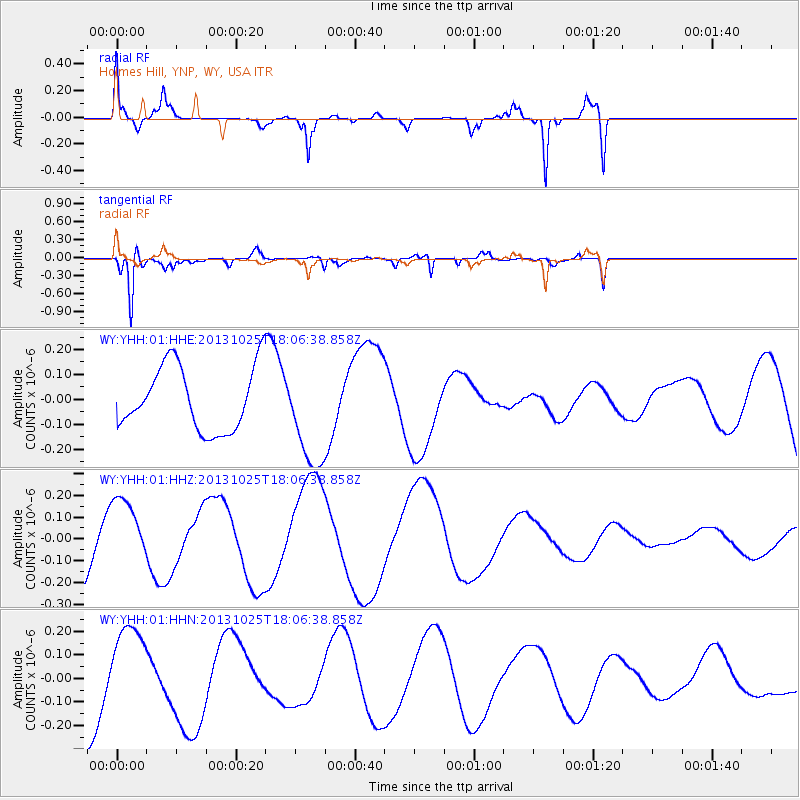
Signal To Noise
| Channel | StoN | STA | LTA |
| WY:YHH:01:HHZ:20131025T18:06:38.858Z | 0.87454957 | 1.6235384E-7 | 1.8564282E-7 |
| WY:YHH:01:HHN:20131025T18:06:38.858Z | 0.90522677 | 1.8463918E-7 | 2.0397009E-7 |
| WY:YHH:01:HHE:20131025T18:06:38.858Z | 1.6060541 | 2.0438702E-7 | 1.2726036E-7 |
| Arrivals |
| Ps | |
| PpPs | |
| PsPs/PpSs | |


