You are here: Home > Network List > TA - USArray Transportable Network (new EarthScope stations) Stations List
> Station A04D Lummi Island, WA, USA > Earthquake Result Viewer
A04D Lummi Island, WA, USA - Earthquake Result Viewer
*The percent match for this event was below the threshold and hence no stack was calculated.
| Earthquake location: |
Aegean Sea |
| Earthquake latitude/longitude: |
39.0/26.3 |
| Earthquake time(UTC): |
2014/12/06 (340) 01:45:07 GMT |
| Earthquake Depth: |
16 km |
| Earthquake Magnitude: |
5.1 MW, 5.3 mb, 4.4 MS |
| Earthquake Catalog/Contributor: |
ISC/ISC |
|
| Network: |
TA USArray Transportable Network (new EarthScope stations) |
| Station: |
A04D Lummi Island, WA, USA |
| Lat/Lon: |
48.72 N/122.71 W |
| Elevation: |
13 m |
|
| Distance: |
88.4 deg |
| Az: |
340.041 deg |
| Baz: |
23.684 deg |
| Ray Param: |
$rayparam |
*The percent match for this event was below the threshold and hence was not used in the summary stack. |
|
| Radial Match: |
64.40433 % |
| Radial Bump: |
400 |
| Transverse Match: |
59.32193 % |
| Transverse Bump: |
400 |
| SOD ConfigId: |
3390531 |
| Insert Time: |
2019-04-15 09:16:53.986 +0000 |
| GWidth: |
2.5 |
| Max Bumps: |
400 |
| Tol: |
0.001 |
|
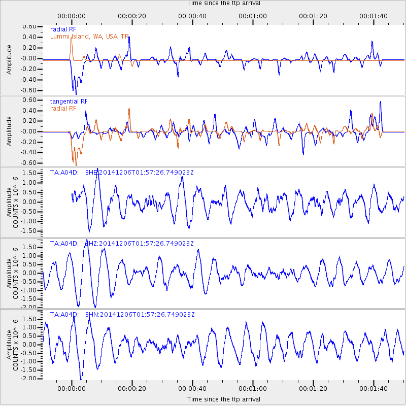
Signal To Noise
| Channel | StoN | STA | LTA |
| TA:A04D: :BHZ:20141206T01:57:26.749023Z | 2.6110592 | 1.2299168E-6 | 4.7104132E-7 |
| TA:A04D: :BHN:20141206T01:57:26.749023Z | 1.6030744 | 1.1330864E-6 | 7.0682086E-7 |
| TA:A04D: :BHE:20141206T01:57:26.749023Z | 0.762731 | 4.9482475E-7 | 6.4875394E-7 |
| Arrivals |
| Ps | |
| PpPs | |
| PsPs/PpSs | |


