You are here: Home > Network List > TA - USArray Transportable Network (new EarthScope stations) Stations List
> Station I49A Point Hope, MI, USA > Earthquake Result Viewer
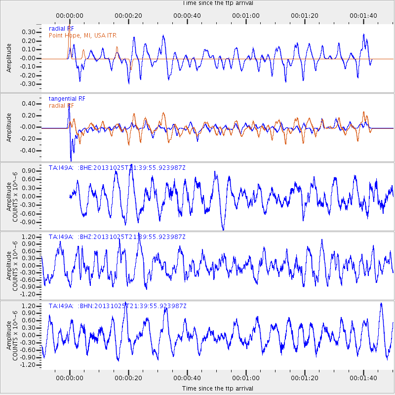
I49A Point Hope, MI, USA - Earthquake Result Viewer
*The percent match for this event was below the threshold and hence no stack was calculated.
| Earthquake location: |
Off East Coast Of Honshu, Japan |
| Earthquake latitude/longitude: |
37.1/144.7 |
| Earthquake time(UTC): |
2013/10/25 (298) 21:27:34 GMT |
| Earthquake Depth: |
10 km |
| Earthquake Magnitude: |
5.5 MB, 5.8 MWC |
| Earthquake Catalog/Contributor: |
NEIC PDE/NEIC COMCAT |
|
| Network: |
TA USArray Transportable Network (new EarthScope stations) |
| Station: |
I49A Point Hope, MI, USA |
| Lat/Lon: |
43.94 N/82.82 W |
| Elevation: |
217 m |
|
| Distance: |
88.6 deg |
| Az: |
32.191 deg |
| Baz: |
323.873 deg |
| Ray Param: |
$rayparam |
*The percent match for this event was below the threshold and hence was not used in the summary stack. |
|
| Radial Match: |
52.01399 % |
| Radial Bump: |
400 |
| Transverse Match: |
68.61684 % |
| Transverse Bump: |
400 |
| SOD ConfigId: |
626651 |
| Insert Time: |
2014-04-19 07:03:51.474 +0000 |
| GWidth: |
2.5 |
| Max Bumps: |
400 |
| Tol: |
0.001 |
|
Signal To Noise
| Channel | StoN | STA | LTA |
| TA:I49A: :BHZ:20131025T21:39:55.923987Z | 0.9715825 | 5.203745E-7 | 5.355948E-7 |
| TA:I49A: :BHN:20131025T21:39:55.923987Z | 0.8239814 | 3.6254715E-7 | 4.3999432E-7 |
| TA:I49A: :BHE:20131025T21:39:55.923987Z | 0.764614 | 3.7377416E-7 | 4.888403E-7 |
| Arrivals |
| Ps | |
| PpPs | |
| PsPs/PpSs | |


