You are here: Home > Network List > UW - Pacific Northwest Regional Seismic Network Stations List
> Station UMAT Pilot Rock, OR, USA > Earthquake Result Viewer
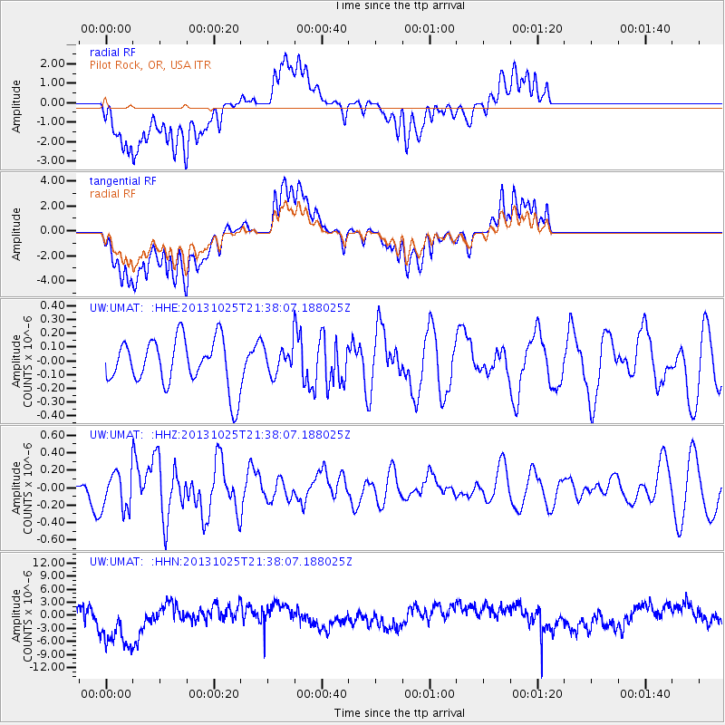
UMAT Pilot Rock, OR, USA - Earthquake Result Viewer
*The percent match for this event was below the threshold and hence no stack was calculated.
| Earthquake location: |
Off East Coast Of Honshu, Japan |
| Earthquake latitude/longitude: |
37.1/144.7 |
| Earthquake time(UTC): |
2013/10/25 (298) 21:27:34 GMT |
| Earthquake Depth: |
10 km |
| Earthquake Magnitude: |
5.5 MB, 5.8 MWC |
| Earthquake Catalog/Contributor: |
NEIC PDE/NEIC COMCAT |
|
| Network: |
UW Pacific Northwest Regional Seismic Network |
| Station: |
UMAT Pilot Rock, OR, USA |
| Lat/Lon: |
45.29 N/118.96 W |
| Elevation: |
1318 m |
|
| Distance: |
68.7 deg |
| Az: |
48.839 deg |
| Baz: |
301.498 deg |
| Ray Param: |
$rayparam |
*The percent match for this event was below the threshold and hence was not used in the summary stack. |
|
| Radial Match: |
55.242607 % |
| Radial Bump: |
400 |
| Transverse Match: |
54.104763 % |
| Transverse Bump: |
400 |
| SOD ConfigId: |
626651 |
| Insert Time: |
2014-04-19 07:11:38.058 +0000 |
| GWidth: |
2.5 |
| Max Bumps: |
400 |
| Tol: |
0.001 |
|
Signal To Noise
| Channel | StoN | STA | LTA |
| UW:UMAT: :HHZ:20131025T21:38:07.188025Z | 1.2982149 | 2.157345E-7 | 1.661778E-7 |
| UW:UMAT: :HHN:20131025T21:38:07.188025Z | 2.3501449 | 6.217736E-6 | 2.6456821E-6 |
| UW:UMAT: :HHE:20131025T21:38:07.188025Z | 0.55989486 | 9.6191975E-8 | 1.7180363E-7 |
| Arrivals |
| Ps | |
| PpPs | |
| PsPs/PpSs | |


