You are here: Home > Network List > AV - Alaska Volcano Observatory Stations List
> Station SPCR Ckakachatna River, Mount Spurr, Alaska > Earthquake Result Viewer
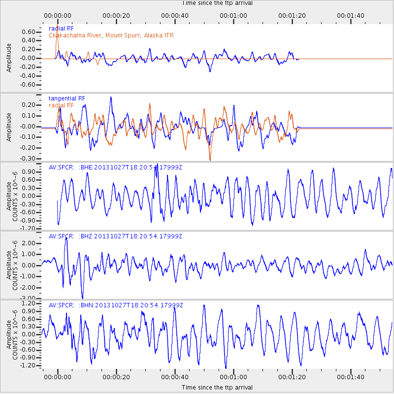
SPCR Ckakachatna River, Mount Spurr, Alaska - Earthquake Result Viewer
*The percent match for this event was below the threshold and hence no stack was calculated.
| Earthquake location: |
Off East Coast Of Honshu, Japan |
| Earthquake latitude/longitude: |
37.1/144.6 |
| Earthquake time(UTC): |
2013/10/27 (300) 18:13:06 GMT |
| Earthquake Depth: |
20 km |
| Earthquake Magnitude: |
5.5 MWB, 5.7 MWC |
| Earthquake Catalog/Contributor: |
NEIC PDE/NEIC COMCAT |
|
| Network: |
AV Alaska Volcano Observatory |
| Station: |
SPCR Ckakachatna River, Mount Spurr, Alaska |
| Lat/Lon: |
61.20 N/152.21 W |
| Elevation: |
984 m |
|
| Distance: |
45.6 deg |
| Az: |
37.243 deg |
| Baz: |
268.034 deg |
| Ray Param: |
$rayparam |
*The percent match for this event was below the threshold and hence was not used in the summary stack. |
|
| Radial Match: |
56.45061 % |
| Radial Bump: |
400 |
| Transverse Match: |
45.722607 % |
| Transverse Bump: |
400 |
| SOD ConfigId: |
626651 |
| Insert Time: |
2014-04-19 07:18:57.238 +0000 |
| GWidth: |
2.5 |
| Max Bumps: |
400 |
| Tol: |
0.001 |
|
Signal To Noise
| Channel | StoN | STA | LTA |
| AV:SPCR: :BHZ:20131027T18:20:54.17999Z | 3.7525563 | 1.1873552E-6 | 3.1641235E-7 |
| AV:SPCR: :BHN:20131027T18:20:54.17999Z | 0.9046074 | 3.4448064E-7 | 3.8080677E-7 |
| AV:SPCR: :BHE:20131027T18:20:54.17999Z | 1.4626666 | 5.7236997E-7 | 3.9131947E-7 |
| Arrivals |
| Ps | |
| PpPs | |
| PsPs/PpSs | |


