You are here: Home > Network List > IW - Intermountain West Stations List
> Station IMW Indian Meadow, Wyoming, USA > Earthquake Result Viewer
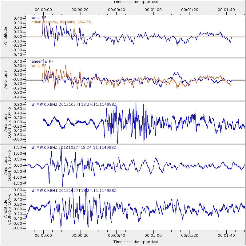
IMW Indian Meadow, Wyoming, USA - Earthquake Result Viewer
*The percent match for this event was below the threshold and hence no stack was calculated.
| Earthquake location: |
Off East Coast Of Honshu, Japan |
| Earthquake latitude/longitude: |
37.1/144.6 |
| Earthquake time(UTC): |
2013/10/27 (300) 18:13:06 GMT |
| Earthquake Depth: |
20 km |
| Earthquake Magnitude: |
5.5 MWB, 5.7 MWC |
| Earthquake Catalog/Contributor: |
NEIC PDE/NEIC COMCAT |
|
| Network: |
IW Intermountain West |
| Station: |
IMW Indian Meadow, Wyoming, USA |
| Lat/Lon: |
43.90 N/110.94 W |
| Elevation: |
2646 m |
|
| Distance: |
74.3 deg |
| Az: |
46.634 deg |
| Baz: |
306.471 deg |
| Ray Param: |
$rayparam |
*The percent match for this event was below the threshold and hence was not used in the summary stack. |
|
| Radial Match: |
63.759823 % |
| Radial Bump: |
400 |
| Transverse Match: |
60.36755 % |
| Transverse Bump: |
400 |
| SOD ConfigId: |
626651 |
| Insert Time: |
2014-04-19 07:28:08.645 +0000 |
| GWidth: |
2.5 |
| Max Bumps: |
400 |
| Tol: |
0.001 |
|
Signal To Noise
| Channel | StoN | STA | LTA |
| IW:IMW:00:BHZ:20131027T18:24:11.114988Z | 5.489417 | 5.219899E-7 | 9.509022E-8 |
| IW:IMW:00:BH1:20131027T18:24:11.114988Z | 2.2617543 | 2.5257103E-7 | 1.1167042E-7 |
| IW:IMW:00:BH2:20131027T18:24:11.114988Z | 2.1384044 | 2.4603654E-7 | 1.15056125E-7 |
| Arrivals |
| Ps | |
| PpPs | |
| PsPs/PpSs | |


