You are here: Home > Network List > US - United States National Seismic Network Stations List
> Station GLMI Grayling, Michigan, USA > Earthquake Result Viewer
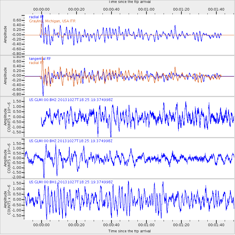
GLMI Grayling, Michigan, USA - Earthquake Result Viewer
*The percent match for this event was below the threshold and hence no stack was calculated.
| Earthquake location: |
Off East Coast Of Honshu, Japan |
| Earthquake latitude/longitude: |
37.1/144.6 |
| Earthquake time(UTC): |
2013/10/27 (300) 18:13:06 GMT |
| Earthquake Depth: |
20 km |
| Earthquake Magnitude: |
5.5 MWB, 5.7 MWC |
| Earthquake Catalog/Contributor: |
NEIC PDE/NEIC COMCAT |
|
| Network: |
US United States National Seismic Network |
| Station: |
GLMI Grayling, Michigan, USA |
| Lat/Lon: |
44.82 N/84.62 W |
| Elevation: |
387 m |
|
| Distance: |
87.1 deg |
| Az: |
32.636 deg |
| Baz: |
322.699 deg |
| Ray Param: |
$rayparam |
*The percent match for this event was below the threshold and hence was not used in the summary stack. |
|
| Radial Match: |
70.749214 % |
| Radial Bump: |
400 |
| Transverse Match: |
64.95619 % |
| Transverse Bump: |
400 |
| SOD ConfigId: |
626651 |
| Insert Time: |
2014-04-19 07:46:00.937 +0000 |
| GWidth: |
2.5 |
| Max Bumps: |
400 |
| Tol: |
0.001 |
|
Signal To Noise
| Channel | StoN | STA | LTA |
| US:GLMI:00:BHZ:20131027T18:25:19.374998Z | 2.2089016 | 7.691293E-7 | 3.4819536E-7 |
| US:GLMI:00:BH1:20131027T18:25:19.374998Z | 1.9347564 | 7.959273E-7 | 4.1138372E-7 |
| US:GLMI:00:BH2:20131027T18:25:19.374998Z | 1.4595058 | 6.482841E-7 | 4.4418053E-7 |
| Arrivals |
| Ps | |
| PpPs | |
| PsPs/PpSs | |


