You are here: Home > Network List > US - United States National Seismic Network Stations List
> Station MIAR Mount Ida, Arkansas, USA > Earthquake Result Viewer
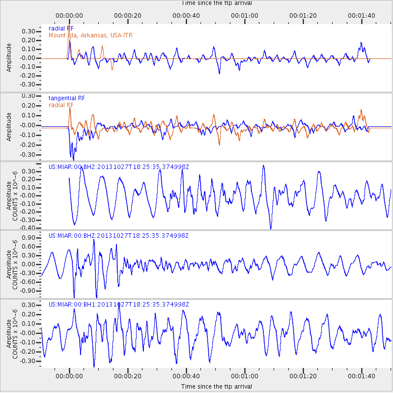
MIAR Mount Ida, Arkansas, USA - Earthquake Result Viewer
*The percent match for this event was below the threshold and hence no stack was calculated.
| Earthquake location: |
Off East Coast Of Honshu, Japan |
| Earthquake latitude/longitude: |
37.1/144.6 |
| Earthquake time(UTC): |
2013/10/27 (300) 18:13:06 GMT |
| Earthquake Depth: |
20 km |
| Earthquake Magnitude: |
5.5 MWB, 5.7 MWC |
| Earthquake Catalog/Contributor: |
NEIC PDE/NEIC COMCAT |
|
| Network: |
US United States National Seismic Network |
| Station: |
MIAR Mount Ida, Arkansas, USA |
| Lat/Lon: |
34.55 N/93.58 W |
| Elevation: |
207 m |
|
| Distance: |
90.5 deg |
| Az: |
44.523 deg |
| Baz: |
317.212 deg |
| Ray Param: |
$rayparam |
*The percent match for this event was below the threshold and hence was not used in the summary stack. |
|
| Radial Match: |
61.443775 % |
| Radial Bump: |
400 |
| Transverse Match: |
76.83743 % |
| Transverse Bump: |
400 |
| SOD ConfigId: |
626651 |
| Insert Time: |
2014-04-19 07:46:25.857 +0000 |
| GWidth: |
2.5 |
| Max Bumps: |
400 |
| Tol: |
0.001 |
|
Signal To Noise
| Channel | StoN | STA | LTA |
| US:MIAR:00:BHZ:20131027T18:25:35.374998Z | 1.566078 | 4.2584847E-7 | 2.7192036E-7 |
| US:MIAR:00:BH1:20131027T18:25:35.374998Z | 1.0555936 | 1.1857836E-7 | 1.12333346E-7 |
| US:MIAR:00:BH2:20131027T18:25:35.374998Z | 0.9251514 | 1.6965959E-7 | 1.8338575E-7 |
| Arrivals |
| Ps | |
| PpPs | |
| PsPs/PpSs | |


