You are here: Home > Network List > US - United States National Seismic Network Stations List
> Station MSO Missoula, Montana, USA > Earthquake Result Viewer
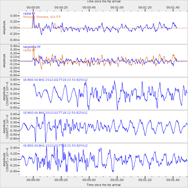
MSO Missoula, Montana, USA - Earthquake Result Viewer
*The percent match for this event was below the threshold and hence no stack was calculated.
| Earthquake location: |
Off East Coast Of Honshu, Japan |
| Earthquake latitude/longitude: |
37.1/144.6 |
| Earthquake time(UTC): |
2013/10/27 (300) 18:13:06 GMT |
| Earthquake Depth: |
20 km |
| Earthquake Magnitude: |
5.5 MWB, 5.7 MWC |
| Earthquake Catalog/Contributor: |
NEIC PDE/NEIC COMCAT |
|
| Network: |
US United States National Seismic Network |
| Station: |
MSO Missoula, Montana, USA |
| Lat/Lon: |
46.83 N/113.94 W |
| Elevation: |
1264 m |
|
| Distance: |
70.9 deg |
| Az: |
45.403 deg |
| Baz: |
303.974 deg |
| Ray Param: |
$rayparam |
*The percent match for this event was below the threshold and hence was not used in the summary stack. |
|
| Radial Match: |
58.019558 % |
| Radial Bump: |
400 |
| Transverse Match: |
34.345005 % |
| Transverse Bump: |
400 |
| SOD ConfigId: |
626651 |
| Insert Time: |
2014-04-19 07:46:30.880 +0000 |
| GWidth: |
2.5 |
| Max Bumps: |
400 |
| Tol: |
0.001 |
|
Signal To Noise
| Channel | StoN | STA | LTA |
| US:MSO:00:BHZ:20131027T18:23:50.82501Z | 2.3075433 | 3.9363928E-7 | 1.7058804E-7 |
| US:MSO:00:BH1:20131027T18:23:50.82501Z | 1.9298927 | 1.4716697E-7 | 7.625656E-8 |
| US:MSO:00:BH2:20131027T18:23:50.82501Z | 1.1205071 | 2.1910415E-7 | 1.9554017E-7 |
| Arrivals |
| Ps | |
| PpPs | |
| PsPs/PpSs | |


