You are here: Home > Network List > UW - Pacific Northwest Regional Seismic Network Stations List
> Station MRBL Marblemount, WA, USA > Earthquake Result Viewer
MRBL Marblemount, WA, USA - Earthquake Result Viewer
*The percent match for this event was below the threshold and hence no stack was calculated.
| Earthquake location: |
Off East Coast Of Honshu, Japan |
| Earthquake latitude/longitude: |
37.1/144.6 |
| Earthquake time(UTC): |
2013/10/27 (300) 18:13:06 GMT |
| Earthquake Depth: |
20 km |
| Earthquake Magnitude: |
5.5 MWB, 5.7 MWC |
| Earthquake Catalog/Contributor: |
NEIC PDE/NEIC COMCAT |
|
| Network: |
UW Pacific Northwest Regional Seismic Network |
| Station: |
MRBL Marblemount, WA, USA |
| Lat/Lon: |
48.52 N/121.48 W |
| Elevation: |
75 m |
|
| Distance: |
65.7 deg |
| Az: |
46.714 deg |
| Baz: |
298.895 deg |
| Ray Param: |
$rayparam |
*The percent match for this event was below the threshold and hence was not used in the summary stack. |
|
| Radial Match: |
61.393982 % |
| Radial Bump: |
400 |
| Transverse Match: |
76.75576 % |
| Transverse Bump: |
400 |
| SOD ConfigId: |
626651 |
| Insert Time: |
2014-04-19 07:48:53.462 +0000 |
| GWidth: |
2.5 |
| Max Bumps: |
400 |
| Tol: |
0.001 |
|
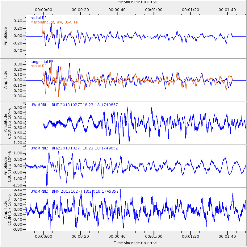
Signal To Noise
| Channel | StoN | STA | LTA |
| UW:MRBL: :BHZ:20131027T18:23:18.174985Z | 3.4347382 | 5.8225487E-7 | 1.6951942E-7 |
| UW:MRBL: :BHN:20131027T18:23:18.174985Z | 1.2825402 | 2.6400667E-7 | 2.058467E-7 |
| UW:MRBL: :BHE:20131027T18:23:18.174985Z | 1.5461664 | 3.1778964E-7 | 2.0553392E-7 |
| Arrivals |
| Ps | |
| PpPs | |
| PsPs/PpSs | |


