You are here: Home > Network List > XL12 - Hangay Dome, Mongolia Stations List
> Station AT02 AT02 > Earthquake Result Viewer
AT02 AT02 - Earthquake Result Viewer
| Earthquake location: |
Banda Sea |
| Earthquake latitude/longitude: |
-6.1/130.5 |
| Earthquake time(UTC): |
2014/12/06 (340) 22:05:10 GMT |
| Earthquake Depth: |
117 km |
| Earthquake Magnitude: |
6.0 MB |
| Earthquake Catalog/Contributor: |
NEIC PDE/NEIC COMCAT |
|
| Network: |
XL Hangay Dome, Mongolia |
| Station: |
AT02 AT02 |
| Lat/Lon: |
45.56 N/94.36 E |
| Elevation: |
2113 m |
|
| Distance: |
60.7 deg |
| Az: |
331.658 deg |
| Baz: |
137.784 deg |
| Ray Param: |
0.060996376 |
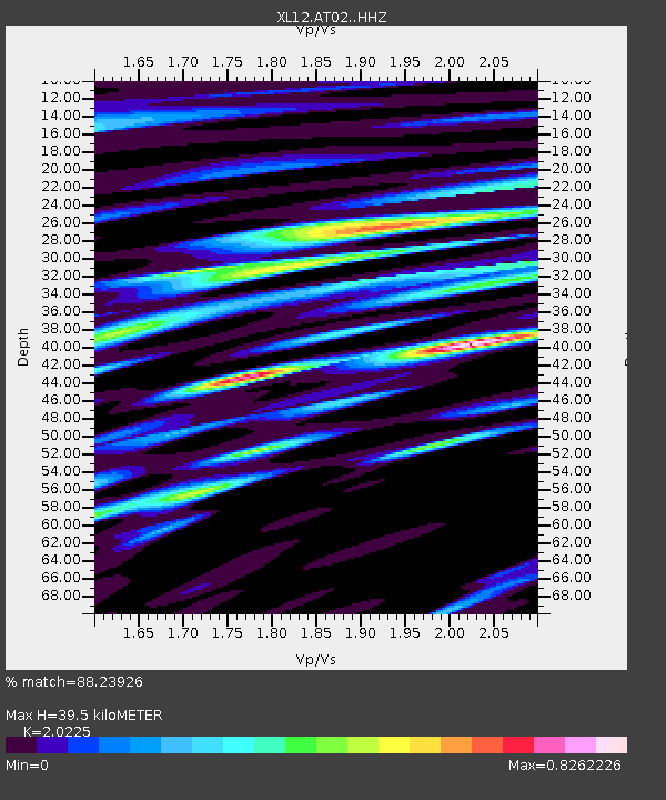
| Estimated Moho Depth: |
39.5 km |
| Estimated Crust Vp/Vs: |
2.02 |
| Assumed Crust Vp: |
6.353 km/s |
| Estimated Crust Vs: |
3.141 km/s |
| Estimated Crust Poisson's Ratio: |
0.34 |
|
| Radial Match: |
88.23926 % |
| Radial Bump: |
400 |
| Transverse Match: |
73.365486 % |
| Transverse Bump: |
400 |
| SOD ConfigId: |
3390531 |
| Insert Time: |
2019-04-15 09:35:25.835 +0000 |
| GWidth: |
2.5 |
| Max Bumps: |
400 |
| Tol: |
0.001 |
|

Signal To Noise
| Channel | StoN | STA | LTA |
| XL:AT02: :HHZ:20141206T22:14:39.300029Z | 29.96818 | 3.086567E-6 | 1.0299481E-7 |
| XL:AT02: :HHN:20141206T22:14:39.300029Z | 8.699819 | 1.8207655E-6 | 2.0928776E-7 |
| XL:AT02: :HHE:20141206T22:14:39.300029Z | 7.4964423 | 1.3169594E-6 | 1.7567791E-7 |
| Arrivals |
| Ps | 6.6 SECOND |
| PpPs | 18 SECOND |
| PsPs/PpSs | 25 SECOND |


