You are here: Home > Network List > TA - USArray Transportable Network (new EarthScope stations) Stations List
> Station R56A Bull Pasture Mountain, McDowell, VA, USA > Earthquake Result Viewer
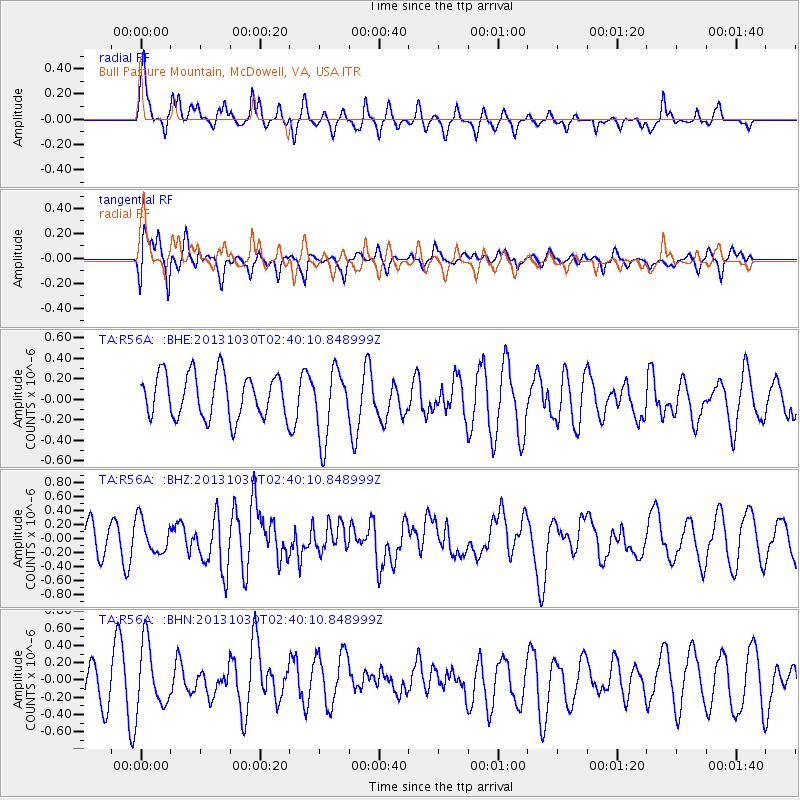
R56A Bull Pasture Mountain, McDowell, VA, USA - Earthquake Result Viewer
*The percent match for this event was below the threshold and hence no stack was calculated.
| Earthquake location: |
Off Coast Of Central Chile |
| Earthquake latitude/longitude: |
-35.4/-73.2 |
| Earthquake time(UTC): |
2013/10/30 (303) 02:29:12 GMT |
| Earthquake Depth: |
39 km |
| Earthquake Magnitude: |
5.8 MWW, 5.8 MWW, 5.8 MWB, 5.9 MWC |
| Earthquake Catalog/Contributor: |
NEIC PDE/NEIC COMCAT |
|
| Network: |
TA USArray Transportable Network (new EarthScope stations) |
| Station: |
R56A Bull Pasture Mountain, McDowell, VA, USA |
| Lat/Lon: |
38.41 N/79.40 W |
| Elevation: |
902 m |
|
| Distance: |
73.7 deg |
| Az: |
354.92 deg |
| Baz: |
174.72 deg |
| Ray Param: |
$rayparam |
*The percent match for this event was below the threshold and hence was not used in the summary stack. |
|
| Radial Match: |
74.354485 % |
| Radial Bump: |
393 |
| Transverse Match: |
64.66747 % |
| Transverse Bump: |
400 |
| SOD ConfigId: |
626651 |
| Insert Time: |
2014-04-19 08:10:44.402 +0000 |
| GWidth: |
2.5 |
| Max Bumps: |
400 |
| Tol: |
0.001 |
|
Signal To Noise
| Channel | StoN | STA | LTA |
| TA:R56A: :BHZ:20131030T02:40:10.848999Z | 1.2941943 | 2.3980118E-7 | 1.8528992E-7 |
| TA:R56A: :BHN:20131030T02:40:10.848999Z | 2.5687613 | 3.8438986E-7 | 1.4964016E-7 |
| TA:R56A: :BHE:20131030T02:40:10.848999Z | 1.5952234 | 3.4030887E-7 | 2.1332991E-7 |
| Arrivals |
| Ps | |
| PpPs | |
| PsPs/PpSs | |


