You are here: Home > Network List > US - United States National Seismic Network Stations List
> Station DGMT Dagmar, Montana, USA > Earthquake Result Viewer
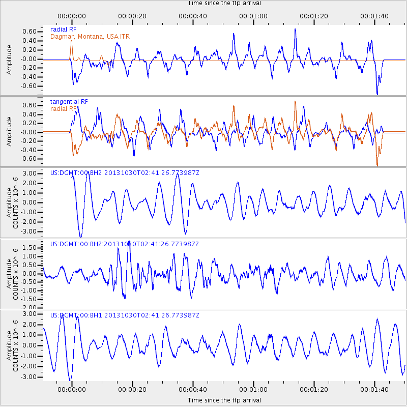
DGMT Dagmar, Montana, USA - Earthquake Result Viewer
*The percent match for this event was below the threshold and hence no stack was calculated.
| Earthquake location: |
Off Coast Of Central Chile |
| Earthquake latitude/longitude: |
-35.4/-73.2 |
| Earthquake time(UTC): |
2013/10/30 (303) 02:29:12 GMT |
| Earthquake Depth: |
39 km |
| Earthquake Magnitude: |
5.8 MWW, 5.8 MWW, 5.8 MWB, 5.9 MWC |
| Earthquake Catalog/Contributor: |
NEIC PDE/NEIC COMCAT |
|
| Network: |
US United States National Seismic Network |
| Station: |
DGMT Dagmar, Montana, USA |
| Lat/Lon: |
48.47 N/104.20 W |
| Elevation: |
0.0 m |
|
| Distance: |
88.0 deg |
| Az: |
339.941 deg |
| Baz: |
155.112 deg |
| Ray Param: |
$rayparam |
*The percent match for this event was below the threshold and hence was not used in the summary stack. |
|
| Radial Match: |
37.416656 % |
| Radial Bump: |
387 |
| Transverse Match: |
45.11564 % |
| Transverse Bump: |
400 |
| SOD ConfigId: |
626651 |
| Insert Time: |
2014-04-19 08:12:48.257 +0000 |
| GWidth: |
2.5 |
| Max Bumps: |
400 |
| Tol: |
0.001 |
|
Signal To Noise
| Channel | StoN | STA | LTA |
| US:DGMT:00:BHZ:20131030T02:41:26.773987Z | 0.80162567 | 2.4854822E-7 | 3.1005524E-7 |
| US:DGMT:00:BH1:20131030T02:41:26.773987Z | 1.7489548 | 2.0168363E-6 | 1.1531666E-6 |
| US:DGMT:00:BH2:20131030T02:41:26.773987Z | 1.1578423 | 1.6899368E-6 | 1.459557E-6 |
| Arrivals |
| Ps | |
| PpPs | |
| PsPs/PpSs | |


