You are here: Home > Network List > UU - University of Utah Regional Network Stations List
> Station VRUT Veyo Road, Veyo, UT, USA > Earthquake Result Viewer
VRUT Veyo Road, Veyo, UT, USA - Earthquake Result Viewer
| Earthquake location: |
Off Coast Of Central Chile |
| Earthquake latitude/longitude: |
-35.3/-73.4 |
| Earthquake time(UTC): |
2013/10/30 (303) 02:51:47 GMT |
| Earthquake Depth: |
42 km |
| Earthquake Magnitude: |
6.2 MWW, 6.1 MWB, 6.2 MWW, 6.2 MWC, 6.3 MWC |
| Earthquake Catalog/Contributor: |
NEIC PDE/NEIC COMCAT |
|
| Network: |
UU University of Utah Regional Network |
| Station: |
VRUT Veyo Road, Veyo, UT, USA |
| Lat/Lon: |
37.46 N/113.86 W |
| Elevation: |
1874 m |
|
| Distance: |
81.6 deg |
| Az: |
328.532 deg |
| Baz: |
147.553 deg |
| Ray Param: |
0.04742688 |
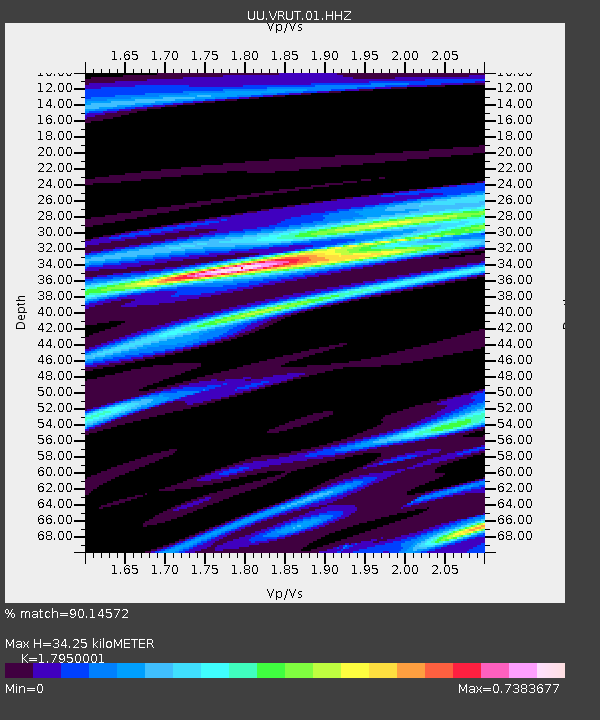
| Estimated Moho Depth: |
34.25 km |
| Estimated Crust Vp/Vs: |
1.80 |
| Assumed Crust Vp: |
6.194 km/s |
| Estimated Crust Vs: |
3.451 km/s |
| Estimated Crust Poisson's Ratio: |
0.27 |
|
| Radial Match: |
90.14572 % |
| Radial Bump: |
288 |
| Transverse Match: |
45.48182 % |
| Transverse Bump: |
400 |
| SOD ConfigId: |
626651 |
| Insert Time: |
2014-04-19 08:32:36.852 +0000 |
| GWidth: |
2.5 |
| Max Bumps: |
400 |
| Tol: |
0.001 |
|

Signal To Noise
| Channel | StoN | STA | LTA |
| UU:VRUT:01:HHZ:20131030T03:03:29.299988Z | 1.7326095 | 4.5879784E-9 | 2.6480165E-9 |
| UU:VRUT:01:HHN:20131030T03:03:29.299988Z | 1.5030892 | 6.1657914E-9 | 4.1020796E-9 |
| UU:VRUT:01:HHE:20131030T03:03:29.299988Z | 1.8148987 | 9.047431E-9 | 4.985089E-9 |
| Arrivals |
| Ps | 4.5 SECOND |
| PpPs | 15 SECOND |
| PsPs/PpSs | 20 SECOND |


