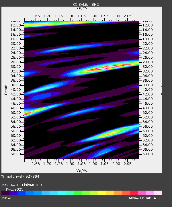
BALB Balikesir-Turkiye - Earthquake Result Viewer

Earthquake location: Taiwan
Earthquake latitude/longitude: 23.6/121.4
Earthquake time(UTC): 2013/10/31 (304) 12:02:08 GMT
Earthquake Depth: 10 km
Earthquake Magnitude: 6.3 MWW, 6.2 MWB, 6.3 MWW, 6.3 MWC, 6.7 MI
Earthquake Catalog/Contributor: NEIC PDE/NEIC COMCAT
Network: KO Kandilli Observatory Digital Broadband Seismic Network
Station: BALB Balikesir-Turkiye
Lat/Lon: 39.64 N/27.88 E
Elevation: 120 m
Distance: 77.9 deg
Az: 307.994 deg
Baz: 69.44 deg
Ray Param: 0.049979888
Estimated Moho Depth: 30.0 km
Estimated Crust Vp/Vs: 1.96
Assumed Crust Vp: 6.155 km/s
Estimated Crust Vs: 3.136 km/s
Estimated Crust Poisson's Ratio: 0.32
Radial Match: 87.927864 %
Radial Bump: 366
Transverse Match: 85.12723 %
Transverse Bump: 400
SOD ConfigId: 626651
Insert Time: 2014-04-19 08:46:21.839 +0000
GWidth: 2.5
Max Bumps: 400
Tol: 0.001

Signal To Noise

ChannelStoNSTALTA
KO:BALB: :BHZ:20131031T12:13:35.500029Z8.1202153.2388127E-63.98858E-7
KO:BALB: :BHN:20131031T12:13:35.500029Z2.12501456.435576E-73.0284855E-7
KO:BALB: :BHE:20131031T12:13:35.500029Z2.47982769.4162704E-73.7971472E-7
Arrivals
Ps4.8 SECOND
PpPs14 SECOND
PsPs/PpSs19 SECOND