You are here: Home > Network List > KR - Kyrgyz Digital Network Stations List
> Station BOOM Boom, Kyrgyzstan > Earthquake Result Viewer
BOOM Boom, Kyrgyzstan - Earthquake Result Viewer
| Earthquake location: |
Taiwan |
| Earthquake latitude/longitude: |
23.6/121.4 |
| Earthquake time(UTC): |
2013/10/31 (304) 12:02:08 GMT |
| Earthquake Depth: |
10 km |
| Earthquake Magnitude: |
6.3 MWW, 6.2 MWB, 6.3 MWW, 6.3 MWC, 6.7 MI |
| Earthquake Catalog/Contributor: |
NEIC PDE/NEIC COMCAT |
|
| Network: |
KR Kyrgyz Digital Network |
| Station: |
BOOM Boom, Kyrgyzstan |
| Lat/Lon: |
42.49 N/75.94 E |
| Elevation: |
1737 m |
|
| Distance: |
42.0 deg |
| Az: |
307.929 deg |
| Baz: |
101.946 deg |
| Ray Param: |
0.0734512 |
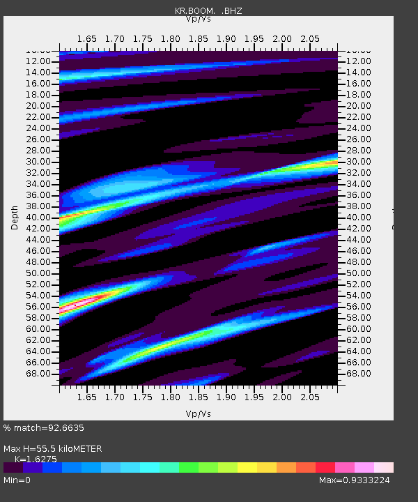
| Estimated Moho Depth: |
55.5 km |
| Estimated Crust Vp/Vs: |
1.63 |
| Assumed Crust Vp: |
6.306 km/s |
| Estimated Crust Vs: |
3.875 km/s |
| Estimated Crust Poisson's Ratio: |
0.20 |
|
| Radial Match: |
92.6635 % |
| Radial Bump: |
313 |
| Transverse Match: |
83.72754 % |
| Transverse Bump: |
400 |
| SOD ConfigId: |
626651 |
| Insert Time: |
2014-04-19 08:46:37.724 +0000 |
| GWidth: |
2.5 |
| Max Bumps: |
400 |
| Tol: |
0.001 |
|

Signal To Noise
| Channel | StoN | STA | LTA |
| KR:BOOM: :BHZ:20131031T12:09:28.924987Z | 5.0120525 | 4.5976628E-7 | 9.173213E-8 |
| KR:BOOM: :BHN:20131031T12:09:28.924987Z | 0.8069382 | 7.608774E-8 | 9.4291906E-8 |
| KR:BOOM: :BHE:20131031T12:09:28.924987Z | 2.7913473 | 2.4544653E-7 | 8.79312E-8 |
| Arrivals |
| Ps | 5.9 SECOND |
| PpPs | 22 SECOND |
| PsPs/PpSs | 27 SECOND |


