You are here: Home > Network List > TA - USArray Transportable Network (new EarthScope stations) Stations List
> Station J05D Fort Rock, OR, USA > Earthquake Result Viewer
J05D Fort Rock, OR, USA - Earthquake Result Viewer
| Earthquake location: |
Taiwan |
| Earthquake latitude/longitude: |
23.6/121.4 |
| Earthquake time(UTC): |
2013/10/31 (304) 12:02:08 GMT |
| Earthquake Depth: |
10 km |
| Earthquake Magnitude: |
6.3 MWW, 6.2 MWB, 6.3 MWW, 6.3 MWC, 6.7 MI |
| Earthquake Catalog/Contributor: |
NEIC PDE/NEIC COMCAT |
|
| Network: |
TA USArray Transportable Network (new EarthScope stations) |
| Station: |
J05D Fort Rock, OR, USA |
| Lat/Lon: |
43.28 N/121.23 W |
| Elevation: |
1541 m |
|
| Distance: |
92.0 deg |
| Az: |
40.478 deg |
| Baz: |
305.36 deg |
| Ray Param: |
0.04151762 |
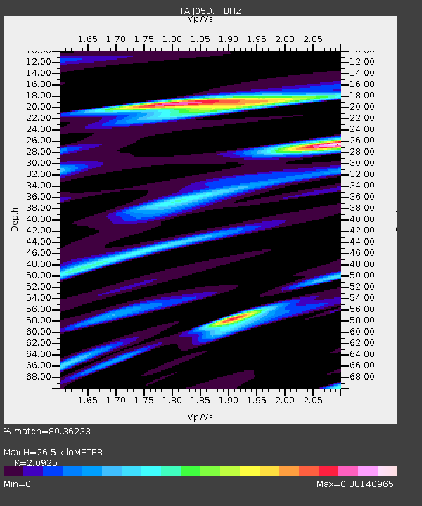
| Estimated Moho Depth: |
26.5 km |
| Estimated Crust Vp/Vs: |
2.09 |
| Assumed Crust Vp: |
6.597 km/s |
| Estimated Crust Vs: |
3.153 km/s |
| Estimated Crust Poisson's Ratio: |
0.35 |
|
| Radial Match: |
80.36233 % |
| Radial Bump: |
400 |
| Transverse Match: |
64.89748 % |
| Transverse Bump: |
400 |
| SOD ConfigId: |
626651 |
| Insert Time: |
2014-04-19 08:50:39.632 +0000 |
| GWidth: |
2.5 |
| Max Bumps: |
400 |
| Tol: |
0.001 |
|

Signal To Noise
| Channel | StoN | STA | LTA |
| TA:J05D: :BHZ:20131031T12:14:46.19998Z | 3.7513673 | 5.7796854E-7 | 1.5406876E-7 |
| TA:J05D: :BHN:20131031T12:14:46.19998Z | 1.0648321 | 2.7682913E-7 | 2.5997443E-7 |
| TA:J05D: :BHE:20131031T12:14:46.19998Z | 0.62178403 | 1.2466778E-7 | 2.0050014E-7 |
| Arrivals |
| Ps | 4.5 SECOND |
| PpPs | 12 SECOND |
| PsPs/PpSs | 17 SECOND |


