You are here: Home > Network List > US - United States National Seismic Network Stations List
> Station HAWA Hanford, Washington, USA > Earthquake Result Viewer
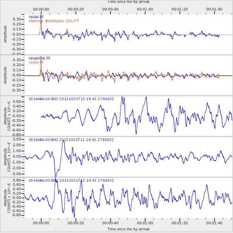
HAWA Hanford, Washington, USA - Earthquake Result Viewer
*The percent match for this event was below the threshold and hence no stack was calculated.
| Earthquake location: |
Taiwan |
| Earthquake latitude/longitude: |
23.6/121.4 |
| Earthquake time(UTC): |
2013/10/31 (304) 12:02:08 GMT |
| Earthquake Depth: |
10 km |
| Earthquake Magnitude: |
6.3 MWW, 6.2 MWB, 6.3 MWW, 6.3 MWC, 6.7 MI |
| Earthquake Catalog/Contributor: |
NEIC PDE/NEIC COMCAT |
|
| Network: |
US United States National Seismic Network |
| Station: |
HAWA Hanford, Washington, USA |
| Lat/Lon: |
46.39 N/119.53 W |
| Elevation: |
364 m |
|
| Distance: |
91.2 deg |
| Az: |
37.251 deg |
| Baz: |
306.648 deg |
| Ray Param: |
$rayparam |
*The percent match for this event was below the threshold and hence was not used in the summary stack. |
|
| Radial Match: |
79.25388 % |
| Radial Bump: |
400 |
| Transverse Match: |
70.92746 % |
| Transverse Bump: |
400 |
| SOD ConfigId: |
626651 |
| Insert Time: |
2014-04-19 08:51:48.867 +0000 |
| GWidth: |
2.5 |
| Max Bumps: |
400 |
| Tol: |
0.001 |
|
Signal To Noise
| Channel | StoN | STA | LTA |
| US:HAWA:00:BHZ:20131031T12:14:42.274993Z | 5.019455 | 6.8506034E-7 | 1.36481E-7 |
| US:HAWA:00:BH1:20131031T12:14:42.274993Z | 1.5213238 | 1.3418465E-7 | 8.8202555E-8 |
| US:HAWA:00:BH2:20131031T12:14:42.274993Z | 1.726375 | 2.4179437E-7 | 1.40059E-7 |
| Arrivals |
| Ps | |
| PpPs | |
| PsPs/PpSs | |


