You are here: Home > Network List > IM - International Miscellaneous Stations Stations List
> Station TX32 TXAR Array, Lajitas, TX, USA > Earthquake Result Viewer
TX32 TXAR Array, Lajitas, TX, USA - Earthquake Result Viewer
| Earthquake location: |
Near Coast Of Central Chile |
| Earthquake latitude/longitude: |
-30.3/-71.5 |
| Earthquake time(UTC): |
2013/10/31 (304) 23:03:59 GMT |
| Earthquake Depth: |
27 km |
| Earthquake Magnitude: |
6.6 MWW, 6.4 MWB, 6.5 MWC, 6.6 MWW, 6.6 MI |
| Earthquake Catalog/Contributor: |
NEIC PDE/NEIC COMCAT |
|
| Network: |
IM International Miscellaneous Stations |
| Station: |
TX32 TXAR Array, Lajitas, TX, USA |
| Lat/Lon: |
29.33 N/103.67 W |
| Elevation: |
1013 m |
|
| Distance: |
66.7 deg |
| Az: |
329.623 deg |
| Baz: |
149.94 deg |
| Ray Param: |
0.05737515 |
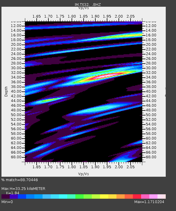
| Estimated Moho Depth: |
33.25 km |
| Estimated Crust Vp/Vs: |
1.94 |
| Assumed Crust Vp: |
6.419 km/s |
| Estimated Crust Vs: |
3.309 km/s |
| Estimated Crust Poisson's Ratio: |
0.32 |
|
| Radial Match: |
88.70446 % |
| Radial Bump: |
400 |
| Transverse Match: |
79.52045 % |
| Transverse Bump: |
400 |
| SOD ConfigId: |
626651 |
| Insert Time: |
2014-04-19 09:00:32.433 +0000 |
| GWidth: |
2.5 |
| Max Bumps: |
400 |
| Tol: |
0.001 |
|

Signal To Noise
| Channel | StoN | STA | LTA |
| IM:TX32: :BHZ:20131031T23:14:17.44998Z | 3.74032 | 1.3564696E-8 | 3.626614E-9 |
| IM:TX32: :BHN:20131031T23:14:17.44998Z | 1.4303886 | 5.674301E-9 | 3.966965E-9 |
| IM:TX32: :BHE:20131031T23:14:17.44998Z | 1.4160296 | 4.288187E-9 | 3.0283174E-9 |
| Arrivals |
| Ps | 5.1 SECOND |
| PpPs | 15 SECOND |
| PsPs/PpSs | 20 SECOND |


