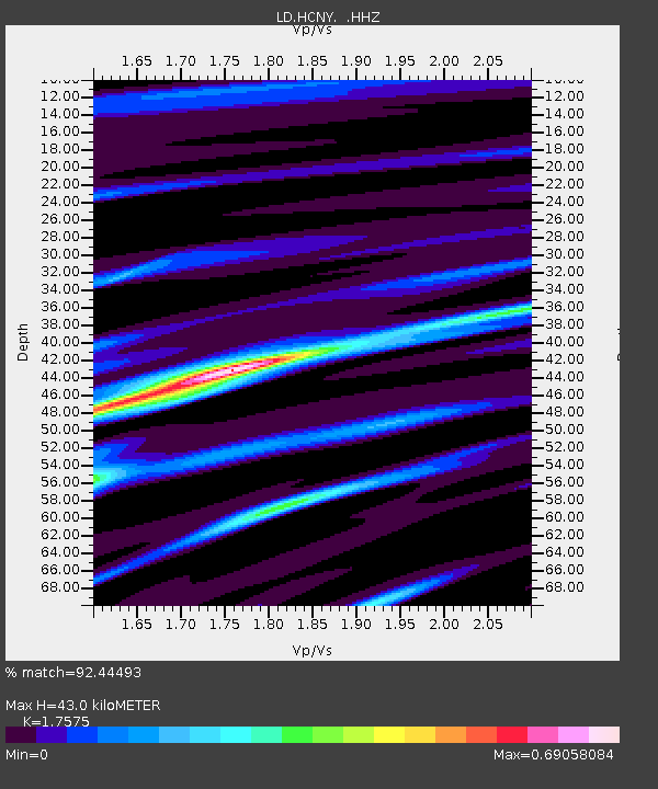
HCNY Howe Caverns, Cobleskill, NY - Earthquake Result Viewer

Earthquake location: Near Coast Of Central Chile
Earthquake latitude/longitude: -30.3/-71.5
Earthquake time(UTC): 2013/10/31 (304) 23:03:59 GMT
Earthquake Depth: 27 km
Earthquake Magnitude: 6.6 MWW, 6.4 MWB, 6.5 MWC, 6.6 MWW, 6.6 MI
Earthquake Catalog/Contributor: NEIC PDE/NEIC COMCAT
Network: LD Lamont-Doherty Cooperative Seismographic Network
Station: HCNY Howe Caverns, Cobleskill, NY
Lat/Lon: 42.70 N/74.40 W
Elevation: 273 m
Distance: 72.7 deg
Az: 357.779 deg
Baz: 177.394 deg
Ray Param: 0.05346795
Estimated Moho Depth: 43.0 km
Estimated Crust Vp/Vs: 1.76
Assumed Crust Vp: 6.419 km/s
Estimated Crust Vs: 3.652 km/s
Estimated Crust Poisson's Ratio: 0.26
Radial Match: 92.44493 %
Radial Bump: 400
Transverse Match: 81.86835 %
Transverse Bump: 400
SOD ConfigId: 626651
Insert Time: 2014-04-19 09:02:27.343 +0000
GWidth: 2.5
Max Bumps: 400
Tol: 0.001

Signal To Noise

ChannelStoNSTALTA
LD:HCNY: :HHZ:20131031T23:14:53.889983Z3.94330127.298815E-71.8509402E-7
LD:HCNY: :HHN:20131031T23:14:53.889983Z1.64661692.758088E-71.6750027E-7
LD:HCNY: :HHE:20131031T23:14:53.889983Z0.827142661.2590966E-71.5222243E-7
Arrivals
Ps5.3 SECOND
PpPs18 SECOND
PsPs/PpSs23 SECOND