You are here: Home > Network List > YT07 - POLENET Stations List
> Station UNGL UNGL > Earthquake Result Viewer
UNGL UNGL - Earthquake Result Viewer
| Earthquake location: |
Solomon Islands |
| Earthquake latitude/longitude: |
-6.5/154.5 |
| Earthquake time(UTC): |
2014/12/07 (341) 01:22:00 GMT |
| Earthquake Depth: |
10 km |
| Earthquake Magnitude: |
6.8 MWP, 6.7 MI, 6.8 MI |
| Earthquake Catalog/Contributor: |
NEIC PDE/NEIC COMCAT |
|
| Network: |
YT POLENET |
| Station: |
UNGL UNGL |
| Lat/Lon: |
79.77 S/82.52 W |
| Elevation: |
745 m |
|
| Distance: |
89.2 deg |
| Az: |
171.383 deg |
| Baz: |
236.426 deg |
| Ray Param: |
0.0420472 |
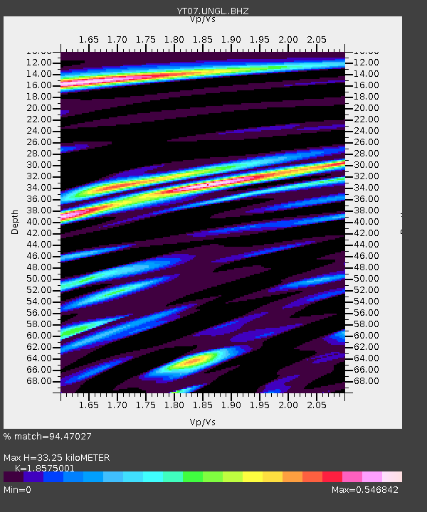
| Estimated Moho Depth: |
33.25 km |
| Estimated Crust Vp/Vs: |
1.86 |
| Assumed Crust Vp: |
6.182 km/s |
| Estimated Crust Vs: |
3.328 km/s |
| Estimated Crust Poisson's Ratio: |
0.30 |
|
| Radial Match: |
94.47027 % |
| Radial Bump: |
400 |
| Transverse Match: |
92.075775 % |
| Transverse Bump: |
400 |
| SOD ConfigId: |
3390531 |
| Insert Time: |
2019-04-15 09:44:00.061 +0000 |
| GWidth: |
2.5 |
| Max Bumps: |
400 |
| Tol: |
0.001 |
|

Signal To Noise
| Channel | StoN | STA | LTA |
| YT:UNGL: :BHZ:20141207T01:34:24.50002Z | 9.90949 | 6.7091133E-7 | 6.770393E-8 |
| YT:UNGL: :BHN:20141207T01:34:24.50002Z | 1.4908532 | 1.2079603E-7 | 8.102477E-8 |
| YT:UNGL: :BHE:20141207T01:34:24.50002Z | 2.5600786 | 1.7941595E-7 | 7.008221E-8 |
| Arrivals |
| Ps | 4.7 SECOND |
| PpPs | 15 SECOND |
| PsPs/PpSs | 20 SECOND |


