You are here: Home > Network List > YT07 - POLENET Stations List
> Station WAIS WAIS > Earthquake Result Viewer
WAIS WAIS - Earthquake Result Viewer
| Earthquake location: |
Solomon Islands |
| Earthquake latitude/longitude: |
-6.5/154.5 |
| Earthquake time(UTC): |
2014/12/07 (341) 01:22:00 GMT |
| Earthquake Depth: |
10 km |
| Earthquake Magnitude: |
6.8 MWP, 6.7 MI, 6.8 MI |
| Earthquake Catalog/Contributor: |
NEIC PDE/NEIC COMCAT |
|
| Network: |
YT POLENET |
| Station: |
WAIS WAIS |
| Lat/Lon: |
79.42 S/111.78 W |
| Elevation: |
1800 m |
|
| Distance: |
84.3 deg |
| Az: |
169.319 deg |
| Baz: |
265.096 deg |
| Ray Param: |
0.045572076 |
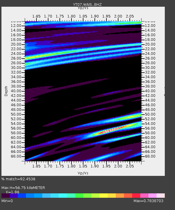
| Estimated Moho Depth: |
56.75 km |
| Estimated Crust Vp/Vs: |
1.96 |
| Assumed Crust Vp: |
5.833 km/s |
| Estimated Crust Vs: |
2.976 km/s |
| Estimated Crust Poisson's Ratio: |
0.32 |
|
| Radial Match: |
92.4536 % |
| Radial Bump: |
363 |
| Transverse Match: |
93.31992 % |
| Transverse Bump: |
400 |
| SOD ConfigId: |
3390531 |
| Insert Time: |
2019-04-15 09:44:01.297 +0000 |
| GWidth: |
2.5 |
| Max Bumps: |
400 |
| Tol: |
0.001 |
|

Signal To Noise
| Channel | StoN | STA | LTA |
| YT:WAIS: :BHZ:20141207T01:34:00.899983Z | 4.330219 | 7.251249E-7 | 1.6745688E-7 |
| YT:WAIS: :BHN:20141207T01:34:00.899983Z | 0.6470107 | 5.7178347E-8 | 8.837311E-8 |
| YT:WAIS: :BHE:20141207T01:34:00.899983Z | 3.2669826 | 2.5064486E-7 | 7.6720596E-8 |
| Arrivals |
| Ps | 9.5 SECOND |
| PpPs | 28 SECOND |
| PsPs/PpSs | 38 SECOND |


